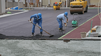
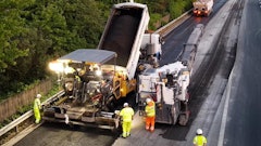
Advanced milling and grading technology recently was tested at John F. Kennedy International Airport. JFK's 13R-31L ("Bay") Runway -- the nation's third-longest at 14,572 ft. -- was resurfaced with an 18-in. layer of concrete. Because JFK is a key component in the nation's commercial air-traffic system, the first phase of the $376.3 million project was put on a fast-track schedule of 120 days.
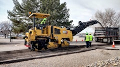
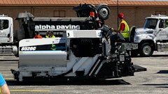
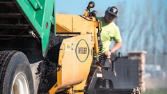
Milling, grading and paving subcontractor Intercounty Paving Associates, LLC of Hicksville, N.Y., kept the first milling phase on track by simultaneously utilizing a combination laser-Global Navigation Satellite System (GNSS) on multiple Roadtec RX-900 cold planers.
GPS puts milling on the fast track
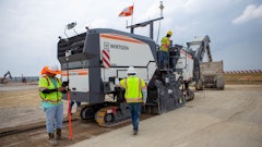
The general contractor, Sylmar, Calif.-based Tutor Perini, was awarded a $204 million contract to widen the runway from 150 to 200 ft. Preparations began during night closures the month before the start date. Tutor Perini surveyors George and Tom Harris localized the jobsite using Intercounty's GR-3 base station from Topcon Positioning Systems.
The roughly 12,000-ft. runway was divided into quadrants about 6,000 ft. in length and 200 ft. wide from the centerline. The 200-ft. widths were subdivided into two adjacent 100-ft.-wide subsections to accommodate eight passes by the 12½-ft.-wide Roadtecs.
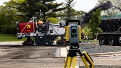
Intercounty had five milling machine rovers and three survey rovers all corrected by a single base station despite being located thousands of feet apart. A three-dimensional site model was loaded into the Roadtecs' machine-control systems.
The original plan was to fine-mill the surface to within three-quarters of an inch of the specified elevation in a single pass using three machines deployed in a staggered formation. The machine making the "virgin cut" would have Millimeter GPS+ controlling both sides of the drum. Each trailing machine would "joint match" on one side using the RX-900's hydromation system, while utilizing Millimeter GPS+ on the other side. Four PZL-1s were spaced apart by 750 ft., affording a pass length of 3,000 ft. before the machines would have to "square up" and return to original starting point.
Equipment blockages and weather caused the Roadtecs to cut to within 0.02 ft. with laser reception and within 0.05 ft. without it. These factors, coupled with severe machine vibration caused by the deep cut in hard material, made precisely milling to the specified elevation in one pass difficult. But the situation turned out to be a blessing in disguise, as it forced Egerter and Intercounty's milling superintendent, Joe La Placa, to devise an alternative process that proved to be even more efficient.
The decision was made to disconnect the laser receivers on three of the Roadtecs and have them rough-mill the existing surface to an inch and a half above finished subgrade. Intercounty's project supervisor, Jim Egerter and La Placa reasoned that since the machines were going to cut the last lift with the Millimeter GPS+ anyway, the rough mill accuracy was not as critical. Three machines cutting without the lasers actually put Intercounty ahead of schedule and two other Roadtecs fine-milled where possible at any given time. The fine-milling machines were set at 18 inches (minus-1.50 feet) and the bulk-milling machines were set at 16¼ inches (minus-1.36 feet). Egerter noted that, after the rough start, Intercounty was hitting the daily production goal of 2,000 by 100 ft. over the past few days.
Intercounty foreman Glen Langdon, spent years as a "side man" working alongside milling machines, raising and lowering the drum as elevation readings dictated. Under conventional elevation-checking methods, reference stations were marked every 25 ft. on a pass, typically along both edges of a pass. Elevation checks utilized tape, stringline and reference marking on the milled surface.
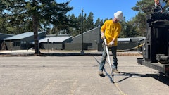
Langdon noted that Millimeter GPS+ was allowing on-demand elevation checks -- in varying locations within a pass -- using GX-60 control boxes and the rover. "With this system, you stick the [rover] anywhere onto the surface and it gives us the number," he said. "It takes a little pressure off [the side men], not having to constantly go up and down with the toggle switch and sensor."
Continuous accuracy
"You could almost say that GPS isn't any more accurate than manual at station, but between stations, it is," says Jim Cleary Intercounty's Topcon dealer, Cleary Machinery Co., Inc., South Bound Brook, N.J. "It performs like a virtual stringline, calculating smooth transitions from station to station. And it eliminates the occasional blown grade."
The system's accuracy prevents over-milling, Langdon points out. "If we're high, we just go back and trim it. If we overcut, we've got to go back and pave and then mill again. That costs time and money."
"The entire area was milled without a single mark on the ground, which is roughly 8,000-plus shots in a 25-by-12-foot grid over 11,000-plus feet," Cleary concluded. "You could assume that two cuts would have been required with any other method, given the hardness of the surface. The mark-out costs associated with 16,000 shots is actually insignificant compared with the potential downtime resulting from waiting for the marks to be made, due to the large penalties enforced for not finishing the job on time. When you consider increased machine productivity and the concrete material savings the accurate milling provided, you could say that these contractors reaped the same benefits that GPS machine control has been providing grading and excavation contractors for the past decade."
Don Talend of Write Results Inc., West Dundee, IL, is a print and e-content developer specializing in construction, technology and innovation.
-------------------
An Elevation Control Alternative
The Topcon Positioning Systems Millimeter GPS+ system is increasingly being used for milling and paving. Just as Millimeter GPS+ has been used for fine grading, contractors are beginning to use it for "fine milling" -- and achieving accuracies within a quarter-inch in contrast to the tenth-of-a foot precision inherent in conventional machine control.
Millimeter GPS+ combines GNSS and laser. In addition to a GNSS base and rover, the system uses a PZL-1 Lazer Zone transmitter and a PZS-MC machine-control sensor or PZS-1 rover sensor that gets integrated with the contractor's GNSS receiver. The PZL-1 transmitter sends out a wall of laser light 33 ft. tall and up to 2,000 ft. in diameter. The contractor can link up to four transmitters for a total reach of 8,000 horizontal ft. and 132 vertical ft. The PZL-1 transmitter can operate multiple machines equipped to accept its signals.
The GNSS component of the system plots the location of the machine while the laser component guides the grader to position and elevate the blade precisely. The system "knows" the three-dimensional position of the laser transmitter and the three-dimensional position of the machine and is then able to calculate the vertical angle from the laser up to the sensor on the machine and provide a vertical correction.