Paving contractors who think they put up with challenging weather should try paving a nearly two-mile-long airport runway at the Eareckson Air Station in the outer reaches of U.S. territory without it.
Eareckson, located on Shemya in the Aleutian Islands off of Alaska, is the westernmost U.S. Air Force base in the chain and is routinely swept by high winds and enveloped in thick fog, even during the summer months when construction is actually feasible.
The tiny island covers only about five miles and straddles the North Pacific Ocean and Bering Sea and, lying about 1,500 miles from Anchorage, is closer to the Russian Federation's Province of Kamchatka than it is to mainland Alaska.
It primarily serves as a refueling stop for military aircraft between North America and Far East Asia and as an emergency landing area.
In early 2009, AECOM Technical Services was awarded a $33 million contract - including $16.2 million under the American Recovery and Reinvestment Act of 2009 - to repair the sole runway, three taxiways and two aprons to handle anticipated heavier use following redeployment of some units from the island of Okinawa. The resurfacing is scheduled for completion by fall 2010.
The 10,000-foot-long, 200-foot-wide runway was originally constructed during World War II; the airfield was originally intended as a B-29 base for the bombing of Japan although, eventually, these missions were assigned to bases in China and the Mariana Islands in the Central Pacific.
The runway had been resurfaced several times over the years and, by 2009, it had severely deteriorated. Anchorage-based Knik Construction, a heavy construction company specializing in remote-site projects in Alaska, the South Pacific and the Caribbean, was hired to mill and repave over the existing asphalt surface.
The task of milling the existing surface appeared to be tailor-made for an advanced machine-control system that Knik had recently heard about.
Utilizing technology
Knik Construction Project Manager Jim Kirsch decided the Topcon Positioning Systems' new Millimeter GPS+ system, which combines three-dimensional Global Navigation Satellite System (GNSS) and a revolutionary new laser technology, would be particularly useful in the challenging weather conditions at Eareckson.
"We had to have such precise accuracy out there, and without setting stringlines," says Kirsch. "It would be difficult to try to have a stringline in the wind, so that's why we decided to go with [the system] and give it a try. There is a lot of wind and a lot of fog and the delays and the amount of labor in setting up the stringlines would have been pretty high-priced."
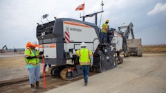
Machine control was not a completely new concept to Knik Construction. The company was already using Topcon's two-dimensional System 5, which uses sonic trackers to set the correct screed height, on its Blaw-Knox PF-5510 paver.
But "Shemya was our first actual 3-D machine control," notes Mike Esquibel, equipment operator and surveyor for Knik. "With the specs that they held us to out there, Ryan (Ryan Sorensen of Edge Survey and Design, Wasilla) and I sat down one day and figured out what it would take to set stringline on something like that. It would have been a full crew all summer - two or three guys doing nothing but setting stringline."
Knik's Topcon dealer, GPS Alaska, located in Eagle River, sold the contractor on the idea of installing the Millimeter GPS system on a milling machine. Knik's new system combines the high vertical accuracy of laser and three-dimensionality of GPS, reportedly increasing accuracy over existing 3-D GNSS-enabled machine-control systems from one-tenth of a foot to one-quarter of an inch.
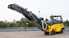
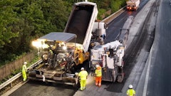
At Eareckson, the milling and paving elevation tolerances were extremely tight: two-hundredths of a foot on the milling and three-hundredths on the paved surface. To address the milling spec, Knik Construction installed the system on a Roadtec RX900 cold planer.
"With the specs they were holding us to on the milling, we had to do something, so we came across the 3-D machine control and we talked to our dealer and they said yes, they could set it up on the mill and we could build a control file and run off of it," says Esquibel.
Sorensen and Knik's grade checker, Sean McCord, topographically surveyed the existing match lines with a rover built the 3-D model using Carlson Civil software based on the official site survey.
"You've still got to build the model, but you definitely don't have any room for error," says Sorensen. "The stress level is quite a bit higher on this type of project. You have a one-shot chance to do the job right. Any mistakes required additional milling and paving. We basically eliminated a four-man crew doing nothing but tearing stringline down and putting stringline up."
Battling the elements
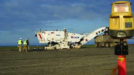
Even armed with its new advanced technology, the Knik crew was at the mercy of the elements at times. The crew arrived during the third week in May 2009 and put up with winds of at least 15 mph every day until departing in late September. At times, the winds reached 80 mph.
Kirsch notes that thick fog reached all the way down to the ground during just about the entire month of July. Occasionally, the fog interfered with satellite signal and laser beam transmission enough to cause work stoppages. The crew milled half of the runway lengthwise, keeping the other half open for incoming and departing flights. Equipment and personnel had to be removed an hour before flights came in or left.
Sorensen and McCord set up the base station on top of the airport control tower, allowing the signal to easily reach any location on the long runway when fog was not an issue. At first, radio signal transmission was insufficient. But Knik's GPS Alaska sales representative, Kevin Silvernale, brought in an LMR 400 cable that improved signal transmission.
The milling depth varied greatly across the pavement due to settling; the runway had not been resurfaced in more than 20 years, according to Sorensen. Pavement thickness ranged from 16 to 30 inches.
"There were times when we'd go from 5 inches of cut down to zero cut within a hundred feet," says Sorensen. "We'd be kind of nervous when you'd look at our cut depths, but then by the time we drove on it, it was very, very smooth - we could find hardly any problems with the asphalt after milling."
In some locations, adds Esquibel, the planer made teeth marks in the asphalt, just barely scratching the surface.
Knik generally managed to avoid overmilling, which would have greatly hindered productivity. "I did my research and made sure that if we went to an area and it was going to be off that it was going to be high," Esquibel says. "When we cross-sectioned, we found a few areas that were a little bit high and shaved those areas back down."
Kirsch estimates that the system reduced milling time by 50%. Because the system allowed one worker to do the job of two to four workers using conventional methods, it likely paid for itself during the first phase of the project.
"It would have been a longer process without the new system," says Esquibel. "We would have had to have a stringline set up and McCord would have had to have his grades written down in his book and go around and measure at certain points and then shoot the grade with a length or rod or a laser. He probably would have pulled his hair out if would have had to do it that way."
Kirsch admits that he was a bit skeptical of the system's accuracy at first. He notes that a few times the signal was lost due to fog.
"We had some spots we had to redo when the thing lost its signal and we had to go back and fill small patches," he says, adding that McCord continually checked grade with the rover while the planer was in operation.
"We were trying to push the envelope of being able to use this system in that weather," says Sorensen. "Especially where we had to make multiple passes and there were short little pulls inside of a radius and the grades changed depending on which direction we were going in, it would have been pretty much impossible to set up stringline and keep up with the grinder - it would have been very difficult to meet the grade specs."


![Screen Shot 2023 01 04 At 5 23 30 Pm[35]](https://img.forconstructionpros.com/files/base/acbm/fcp/image/2023/01/Screen_Shot_2023_01_04_at_5.23.30_PM_35_.63bc42696de27.png?auto=format%2Ccompress&fit=crop&h=135&q=70&w=240)


![Bm 2200 65 Cold Planer Release[17]](https://img.forconstructionpros.com/files/base/acbm/fcp/image/2023/06/BM_2200_65_Cold_Planer_release_17_.649359d81b660.png?auto=format%2Ccompress&fit=crop&h=135&q=70&w=240)