When homes began to be threatened on Taylor's Island on the coast of Delaware Bay, it became clear something had to be done about the shore erosion that had been occuring for decades. A narrow stretch at the tip of Taylor's Island had lost an estimated 200 ft. to erosion since the 1980s, threatening a handful of homes.
Plans had been made to stabilize the shoreline since 2000, with federal funding finally approved in 2007. The Army Corps of Engineers financed 75% of the project, with Dorchester County funding the remaining 25%.
Shoreline Design, Edgewater, MD, was awarded the bid on the $1.5 million project and began work in July 2007. Company owner Wes Matheu previously worked as a project manager for the Army Corps, as well as with several marine contractors, before starting his own company in 2003. He was already familiar with the situation on Taylor's Island.
"I actually looked at this project when I worked for the Corps about 12 years ago and the people out there were trying to get something done," Matheu notes. "The Corps will spend federal dollars on a project as long as it's protecting a federal roadway or public infrastructure."
Over the years, Matheu had seen the erosion the Delaware Bay tides were causing in the area. He also witnessed the efforts to mitigate the erosion while funding was pending. The existing shoreline stabilization material "was kind of haphazardly dumped and it was maybe a couple of feet over the high tide at best," he recalls. "The tide ranges about 2 to 3 ft. in this location, and it's not just the tides. The wind kicks up and the fetch - which is the distance the wind blows across the water to form a wave - is very wide here."
The new revetment wall was designed to have a height of about 3 to 4 ft. higher than the existing material. The toe of the slope at the bottom of the bay is located 36 ft. from the shoreline and is itself 4 ft. wide. The revetment would be a total of about 9 ft. high with a 2:1 slope.
Tricky conditions require accuracy
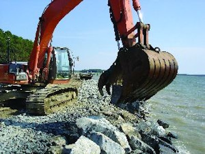
The first task was to take away the existing rock along the shoreline. "The process was to strip the shoreline and sort the debris," says Matheu. "They wanted us to save [the bigger rock] that was 400 lbs. on up. Everything smaller was supposed to be stockpiled in the yard. We used some of the small stuff to rebuild the subgrade, and we would excavate the toe, then cover everything with a layer of No. 2 stone."
Toe construction required excavation of about 2 ft. of soil at the bottom of the bay and placement of armor rock in the excavation. "We never really saw the really low tides," says Matheu. "We always had at least 4 ft. of water we were working with, so you could never see what you were doing when you put the toe in."
For surveying, Shoreline Design brought in its Topcon HiPer Lite+ base station and rover "fourth sensor" utilizing Global Navigation Satellite System (GNSS) technology. The excavator bucket - which held the GNSS rover antenna - was lowered to the surface of the water in order to mark the depth of the subgrade and, later, the elevation of the toe stone.
As a quality control measure, the GNSS was periodically recalibrated to the bucket. "We probably handled about 15,000 to 20,000 tons of rock on this project, so the teeth on the bucket actually wear [down]. The teeth are the measuring point, so occasionally we would recalibrate the bucket and check it against the hand-held [field monitor] just to make sure we were as accurate as we could be," says Matheu.
In addition to surveying, the GNSS was used to verify the elevation of the revetment for inspectors. "Normally, when you do this type of work, you have to put a lot of stakes in the ground, measure up to your 2:1 slope and figure out where the crest of your structure is going to be, which is an imaginary point," Matheu says. "Some agencies require contractors building revetments to build a 2x4 template so that the inspector can look up and down the line to see if you're hitting the right elevation. It's a lot of field work to build one of these. We saved a lot of time that way."
Placing layer upon layer
Following toe construction, the contractor placed an 8-in. revetment layer consisting of No. 2 stone with an average size of 2 to 3 in. Placement of geotextile fabric on this layer turned out to be one of the most difficult tasks on the project.
"We have some tricks," says Matheu. "We had the cloth pre-sewn by one of our subcontractors into panels that were 130-ft. long by 36-ft. wide. We found where the toe was for the structure and we put in 2-in. metal posts, then we would drag the filter cloth out."
The cloth was stretched out on shore, then two workers were sent into the water in wetsuits, even in the winter cold. "The guys in the water got out to where they could hold onto the poles and we had some other guys on the shore who stretched out the cloth," Matheu explains. "We used 3-in. rings and we zip-tied the rings to the filter cloth, then dropped the rings over the fence posts. Then, on land, we would pull that side tight."
Even with the fabric carefully deployed, more finesse was still required for the next 8-in. layer of 4- to 8-in. average-size gabion stone. "Instead of dumping the stone on it, you have to sink the cloth," Matheu notes. "That was labor intensive. Two guys would stand on the cloth and sink it. I would pass a bucket of rocks out there and they would hand throw small rocks until we got the cloth down. That's the trick to getting it down. If you just dump stuff on it, it tugs and pulls and it doesn't go where you want it. Doing it slowly gets it the most even and spread out."
After placing the third layer and checking the grade with the HiPer Lite+, Shoreline Design placed a 2-ft. layer of 400- to 1,200-lb. secondary armor stone. The final "primary armor" layer consisted
of stone weighing 800 to 2,500 lbs.
The GNSS really proved its worth near the end of the project, Matheu reports. "For the last 400 ft. of the project, the elevation of the toe changed. It actually came up 1 ft., which changes the width of the slope because you're 1 ft. lower in height," he says. The company that built the 3-D model for the project, Take Off Pros, Peoria, AZ, incorporated this elevation change into the model.
According to Matheu, grade checking the work without the GNSS would have required the use of stakes and a laser. "I would have had to have somebody in the water with a grade rod," he says. "At least one person who is a surveyor would have had to be out there.
"We would have used a laser level, but just due to limitations of my work force, I would probably have hired a surveyor to come out there," he continues. "The problem with this work is that you don't put in a layer and then call somebody and have someone show up. We probably would have put somebody on the payroll who was more skilled in surveying than any of us."
Ultimately, the use of the HiPer Lite+ GNSS saved time and cost, and made Shoreline Design significantly more productive compared with conventional surveying methods. As a result, the contractor was able to successfully complete the project ahead of the 180-day schedule.