In the last five years, Ellis Astin Grading, Villa Rica, GA, has gone from an $8 million company working on small public projects to a $50 million+ commercial and industrial grading contractor known throughout Georgia and Alabama. Ellis Astin, company president, feels the speedy transition is due in part to his firm's emphasis on high-production, high-quality services.
Ellis Astin Grading has helped excavate and prepare foundations for a wide range of public and private organizations, including manufacturing plants, office space, schools, churches, retail centers, subdivisions and roadways. "In one week, we might excavate or grade as much as 500,000 cu. yds. of dirt," says Astin. "Clearly, we need a top-notch team and tools to keep us performing at this level throughout the year."
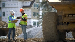
Key in this effort has been the adoption of GPS technology into the company's everyday operations. The technology helps speed and improve accuracy of survey activities that are an integral part of every grading/excavation project.
In with the new
Ellis Astin first invested in GPS technology about two years ago to improve grading efficiency. Since then, the jobs have gotten bigger and the client requirements for speed and accuracy have increased.
"At any one time, we might have 30 jobs ongoing at once. Some of these projects are in excess of 300 acres," says John Sorrell, field engineer and surveyor. "We can't survey these sites with any speed using conventional equipment, and yet we didn't want to invest in the typically more costly surveyor's tools. We had an entry-level GPS system that helped, but simply lacked the power and flexibility of the newer systems."
Last year, Ellis Astin set aside its older GPS products for a new generation of builder's professional measurement equipment. Consisting of an RX900 controller and ATX900 GPS antennas, the all-on-the-pole Leica GPS900 RTK solution is suited for one-person topographic surveys and stakeouts.
Ellis Astin saw almost immediate benefits from its investment. The company had been contracted to complete a four-phase excavation and grading project on a 300-acre site that included a large warehouse and buildings facilities. On the first and second phase, Sorrell and his team initially used conventional total station technology. "I brought the Leica GPS900 to the jobsite soon after it arrived," says Sorrell. Productivity jumped by 40% to 50%.
Part of this productivity gain was attributed to the ability of the GPS to traverse very large sites quickly. "GPS lets us work with greater accuracy very quickly on jobsites of all sizes," he says. "Often, I still need to run boundaries with the total station, but from then on it's GPS."
Using GPS to calculate volumes
On another project, a local Atlanta developer contracted Ellis Astin to grade a 90-acre site for mixed-use residential development. The site included over 800 building pads at varying elevations. Some pads were 50 or 60 ft. higher than others. Each phase of the site was separated with walls ranging from 2 to 30 ft. high.
"Conventional surveying techniques with total stations would have been very slow, requiring us to go through many setups in order to reach all the areas we needed to stake," Sorrell notes.
Instead, Sorrell and his team were able to stake 30 buildings a day. GPS was also used to calculate volume quantities of rock blasted from the site in real time. At the beginning of the project, the team did a topographic survey and marked the volume to a specific elevation. At the end of each week, they could quickly recalculate to the benchmark elevation and, in about 15 minutes, know exactly how much earth was moved.
"We used to have to go back to the office and download the topographic information to a CAD program to calculate volumes. Now we do it on site," Sorrell states. "Even better, we can add more points to an existing volume calculation and recalculate, if necessary — something we were never able to do with conventional survey solutions."
In addition, Sorrell was able to use the GPS900's Nearest Point feature to quickly verify utility locations in each subdivision. The feature automatically looks at all the points yet to be staked out, calculates a distance from the current position to all remaining stakeout points, then selects the shortest distance to the next stakeout point.
"On this project, we checked 100 sewer laterals along the right-of-way for the county inspector, and it took 15 minutes. I just walked to the point, hit one button and it quickly read how close I was to the intended point," says Sorrell. "We use this feature daily. Its compatibility with CAD saves a few steps because there is no need for data conversion.
"Bottom line, GPS is a critical resource to our company," he adds. "We can't afford to do business without it, and fortunately, it's now available at a price point we can support with functionality that exceeds our expectations." ?
Staying Connected
With every GPS tool, the user is at the mercy of the available satellite signals. When those signals get dropped, the equipment must make adjustments to the data — in some cases, with disastrous results.
Ellis Astin's John Sorrell recalls one topographic survey project using a different GPS product. "It was a simple topographic survey of a relatively flat field. I lost the signal from the GPS about halfway through the survey, so I paused and waited for it to return. It did and I moved on," he notes. "During post-processing, I noticed there was a big valley that appeared in the middle of the field. I knew that wasn't right." It turns out the GPS tool had picked up the wrong signal in the middle of the field.
The Leica GPS900, on the other hand, is equipped with SmartCheck, which performs two independent checks — one every four seconds — on the GPS signal. "Our GPS900 ensures we don't have that mistake again," Sorrell states.