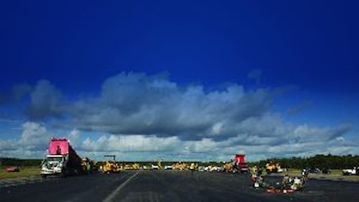
Twenty years of sun, heat, rain, cold, ice, snow and traffic left the runway at the Albert J. Ellis Airport in Jacksonville, NC, showing signs of oxidation and some slight cracking. It was time for rehabilitation of the 7,100-foot runway.
The problem facing the airport commission and the contractor was how to work on the only runway when two commercial airlines operate 12 flights in and out of the airport a day? There were only two alternatives:
1) Work at night over a long period of time, or
2) Close the runway and work non-stop until the work was completed.
Airport Director Jerry Vickers says the project involved milling off one inch of pavement of the 7,400-foot long (including blast pads), 150-foot-wide runway and then overlaying it with two inches of asphalt. To make matters a bit more complicated a 532-foot-long, 48-inch drainage pipe needed to be replaced under the runway.
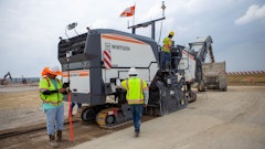
Barnhill Contracting Company, based in Tarboro, NC, was the successful bidder and offered a solution that met the needs of both Vickers and the contract management team of Reynolds, Smith and Hills Inc., an engineering firm based in Jacksonville, FL. Barnhill would use pavers equipped with Topcon Millimeter GPS to complete the job in 60 hours.
“Our issue here was we had a drainage pipe spanning under a section of the runway that had been there quite a number of years and it needed to come out,” Vickers says. “We had to shut down for two and a half days to get the pipe taken care of. The pipe excavation and replacement provided a good opportunity to pave as much of the rest of the runway as we could instead of having to do that at night, in five- and six-hour increments.
“It’s much more efficient for the contractor to muster his resources and do this compressed two and a half day paving schedule,” he explains. The airport was closed Tuesday night through Friday morning because that time period had the fewest travelers.
Ninety five percent of the $4.1 million project was funded through the Federal Aviation Administration’s Airport Improvement Program, 2.5 percent by the North Carolina Department of Transportation’s Division of Aviation, and the remainder of the project was funded by passenger facility charges, which are the surcharges airports impose on tickets sold. “Over the 60-hour shutdown, we spent $3 million of the total funds. That’s the scope and scale of what we did over two and a half days,” Vickers says.
Tackling the project
Mark Collins of Barnhill Contracting Company was the senior project manager for the project and knew at the start that this was a big job, given the designated timeframe. The FAA required Barnhill to hit all the design grades within a half-inch. Because the milling operation was a variable and they could not guarantee the grade they would be working from, Collins and Thumper Swann, Barnhill vice president, believed the only way the project could be completed to specification within the allotted time was to use GPS on the pavers.
Why the Topcon Millimeter GPS? “We had been using GPS on our grading equipment. We knew enough about Millimeter GPS to know its reputation for accuracy and reliability. We knew from talking to others in the industry that you could put the model in and basically take off paving and it would hit what you told it to hit with millimeter accuracy,” Collins says.
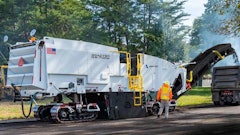
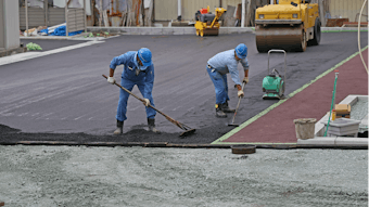
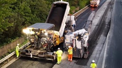
Barnhill’s plan called for paving 25-foot-wide lanes using two pavers. To do this, crews used two sets of pavers, each equipped with the Topcon Millimeter GPS, which provides enhancement in the vertical-measuring precision of RTK (real-time kinematic) positioning systems.
In concert with the Millimeter GPS, Barnhill used Topcon PZL-1 lasers to create a Lazer Zone - a rotating (600 rpm) signal that fans out to a height of 33 feet, creating a “wall of laser light,” Collins says. With Lazer Zone, the resulting integrated system can generate vertical accuracy within a few millimeters, compared to centimeter-level vertical accuracy using conventional RTK GPS systems.
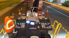
On the airport project, Barnhill was able to set the Millimeter GPS system up quickly, using four Lazer Zone transmitters; one receiver with a LazerZone sensor mounted on a mast attached to the toe arm of each of the four pavers; and two rover receivers each with a Lazer Zone sensor.
A simple set-up procedure allows the Millimeter GPS system to automatically calculate the three-dimensional location of the transmitter, which has a working radius of 1,000 feet. When the transmitter’s signal reaches the sensor, which is mounted on the rover’s GPS antenna, the system decodes the signal and instantly calculates the height differential (transmitter-to-sensor).
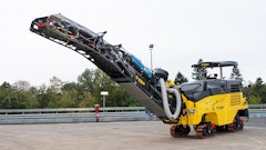
The milling operation started at 8 pm on October 2, 2007, with four machines, explains Mark Eakes, GPS manager for Barnhill. After the milling machines got far enough ahead, the pavers were positioned on the runway.
They used two Topcon PZL-1 lasers on one side and two pavers on the other side, staggered about 20 feet apart, so they could receive the correction signals from the lasers. Following behind one of the pavers in each set, a Topcon HiPer Lite was used to check the grade. Barnhill’s first pass created the centerline crown and paving crews worked outward from that point.
Challenges
This job was not without challenges. Barnhill Contracting Company had extensive experience with GPS systems in their grading operations, but had never used the Millimeter GPS on a paving project (though crews did use it during a test run on a small site). Asphalt paving is a more precise operation, and requires a different skill set.
“This is definitely a team effort,” says Eakes, 22 hours into the project. “It takes what we know about GPS and combines it with what our operators know about paving, along with the organization of our project managers to get it all together. And, of course, the cooperation of all the subcontractors we have working out here who have had to work difficult hours.”
At this point Eakes had been on site 36 hours with only one meal in two days. And it was the same for many of the workers. “You don’t have time to stand around when it’s you and four other guys running all the GPS equipment. Steve Carlyle from our Southeast Division helped me and he does excellent work. It took a lot of participation from a lot of different people to get this done. Our crews worked in 14- and 18-hour shifts, and Chuck Harris from Benchmark Tool & Supply, our Topcon dealer, and his staff went above and beyond what was expected. He and his staff stayed on the job and ran all the GPS equipment so we could get some rest. They jumped right in and became part of our team,” he says.
The hardest part of the job was setting up the paver and the GPS system, what is called the “sit down” to take off at the beginning. Eakes would do things differently the next time.
“Next time I’d try to use two systems versus four,” Eakes says after the project had been completed. “I would still use four lasers but only two machines and two base stations instead of one like we did on this project. I would definitely move the base a third of the way and set one up on each side. We were up for the challenge. There is always room for improvement on anything.
“I would not run as many pavers unless we were running them in different locations, two on one end and two on the other,” he continues. “It has to do with the amount of trucks you can man up. We had 40 trucks on the runway. If I could keep two pavers running nonstop I could probably do just as much production and have less interference and less running around and still complete the project in the same amount of time.
“I learned a lot from the men on the back of those pavers and I plan to use those lessons learned to make our GPS systems an even better tool for the company,” he says.
One lesson learned involved communication. Collins says, “We were trying to run multiple operations while we were still learning the system - milling the asphalt, paving and hauling all at the same time. We found out that this was not a good idea because if you ever block the signal from the laser, it affects your paver. It can be as simple as a dump truck raising its bed. If it’s on that laser it loses signal and then you have to stop until you pick up the signal again.”
Harris of Benchmark Tool & Supply Inc., who sold the Topcon system to Barnhill, agrees. “I was very pleased with the performance of the equipment. Generally, at airports if you have string line, it is constantly in the way of your trucks. The main benefit of this system is doing away with the string line,” Harris says.
The mobility of the Topcon system is a tremendous benefit for a company like Barnhill, which has operations in 13 offices throughout eastern North Carolina.
“All of this equipment is interchangeable and can be used with graders and dozers. We are fortunate to have all this technology and it has made a big impact on our productivity,” Eakes says.
One obstacle that has to be overcome with any new technology is our tendency to resist change.
“You take an operator who has been grading and paving for 20 or 30 years,” Eakes says. “They don’t want to see this stuff. They have been doing it their way for all these years and they don’t need GPS to tell them what to do.
“But if you can get an experienced operator like that to try it, it’s like pulling teeth to get it back once they get on it,” he continues. “They see the benefits, the advantages of having it. It takes all the guess work out of the job and makes their job easier and faster. They don’t have to chase a string line around. It speeds up the progress when it is set up correctly.”
Information provided by Topcon.


![Screen Shot 2023 01 04 At 5 23 30 Pm[35]](https://img.forconstructionpros.com/files/base/acbm/fcp/image/2023/01/Screen_Shot_2023_01_04_at_5.23.30_PM_35_.63bc42696de27.png?auto=format%2Ccompress&fit=crop&h=135&q=70&w=240)


![Bm 2200 65 Cold Planer Release[17]](https://img.forconstructionpros.com/files/base/acbm/fcp/image/2023/06/BM_2200_65_Cold_Planer_release_17_.649359d81b660.png?auto=format%2Ccompress&fit=crop&h=135&q=70&w=240)