Grade control devices utilizing global positioning system (GPS) technology have been available for dozers and motor graders for more than a decade. Yet, they have only recently become available for hydraulic excavators.
"The complex and variable movements of the excavator are the reason for its popularity, and the reason for the lag in a positioning solution," says Randy Noland, machine control product manager for Topcon Positioning Systems.
Several manufacturers now offer GPS-based systems that have converted excavators into fine-grading tools. According to Leica Geosystems, the technology has developed to a level where excavators can supply grading accuracies down to .10 ft. (1 1/4 in.).
Following is a look at some of the recent advancements in GPS-based excavator grade control from several key suppliers, as well as their thoughts on the benefits such systems can provide.
Topcon 3DXi
GPS grade control technology utilizes the Global Navigation Satellite System (GNSS) to pinpoint location and transmit data. Yet, according to Noland, this is only a part of the equation.
"GNSS can monitor the position of a machine on a jobsite and the movements of a blade quite easily," he states. "But when you consider the anatomy of an excavator — with the boom, stick and bucket and their respective motions — combined with the fast 360° movement of the machine itself, it becomes apparent that other 'sensor' technology is required."
Consequently, a heavy focus has been placed on the tilt angle sensor. "The tilt sensor must be durable and reliable in all weather conditions, and must be 'abuse friendly'," says Noland. "These sensors must also be 'social' and talk to one another."
With the Topcon 3DXi 3-D positioning system, tilt sensors are placed on the excavator body, boom, stick and bucket. "The sensors constantly monitor two axes of their respective positions, while instantly talking to each other," Noland explains. "At the same time, this information is communicated back to the control box or computer."
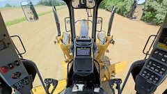
The control box, along with the software, report the convergence of sensor information (GNSS and CAN-based tilt axis) to the excavator operator via the in-cab display screen. The operator then dictates how the excavator responds.
"With 3-D positioning, the operator is able to dig to grade without over-excavating, while verifying the grade progress instantly, even in a blind cut," Noland points out. "This is possible while freeing up the grade checker to perform other tasks."
Other benefits include more accurate material placement, as well as the ability to reference the same data used by other heavy equipment, enabling all operators to be "working from the same page," Noland adds. This leads to increased productivity.
Accuracy of 3-D systems is specified at .20 ft. industry-wide, with costs varying anywhere from $15,000 to $60,000, depending on the levels of functionality required.
Noland comments, "The return on investment from the automated equipment — which can cut the work required for a specified task by half — is fast, so it can be easily justified."
Trimble GCS900
The Trimble GCS900 GPS-based grade control system is an upgraded version of the GCS600 excavator system. The GCS900 with dual GPS can be installed on excavators with standard buckets or tilt buckets for mass excavation projects. The system uses two GPS receivers and solid-state angle sensors to measure the precise 3-D position of the bucket tip.
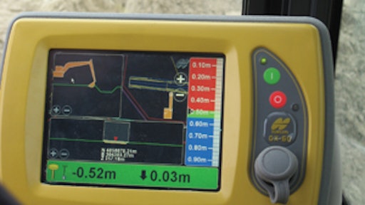
The GCS900 places the site plans directly at the operator's fingertips via the CB430 operator control box. The dual GPS antenna configuration is able to compute the exact position and orientation of the machine blade or bucket. Then, the CB430 determines the position and compares this to the design elevation. Coupled with the in-cab mounted lightbars, the operator can visually see what bucket movement is required to achieve grade, allowing for faster excavation of even complex designs without the need for staking.
The cost of Trimble grade control technology varies widely depending on the machine type, earthwork application and accuracy requirements. Regardless of cost, the company believes the systems provide significant tangible benefits via increased productivity, reduced production costs and material savings.
Leica DigSmart 3D
Leica Geosystems' DigSmart 3D Excavator Guidance System is designed to accurately guide the excavator operator to the proper jobsite location and digging depth. A graphic color monitor in the cab displays the project design information and 3-D GPS position, enabling the operator to set proper bucket elevation and position. Dual GPS antennas are used to pinpoint the exact position of the bucket teeth.
SmartTools operation facilitates easy implementation of the system. For example, the SlopeTool mode automatically adjusts the dig depth information to compensate for machine slope and roll; this, in turn, helps to prevent over excavating. The TrenchTool mode enables the operator to select the center line reference from the design, then key in the desired trench width. The system will then guide the operator where to cut and to what depth.
The system software also offers a high level of integration with survey data from the company's line of survey instruments. The work can be surveyed with a total station or GPS rover, and the data transferred directly to the excavator.
According to Leica, there are several benefits to implementing 3-D GPS technology, including:
- It empowers the operator to know where to dig and to what grade anywhere on the job by placing the job plans directly in the cab.
- It results in a vast reduction in staking and re-staking requirements.
- Overall efficiency is improved via reduced downtime associated with waiting for survey control, re-staking and grade checking.
- Cost savings can be realized via reduced re-work, minimal staking/re-staking, savings on materials and improved operating efficiency.
Caterpillar AccuGrade
Caterpillar is preparing to launch its first excavators and backhoe-loaders with laser and GPS machine control and guidance technologies integrated into the machines, available from the factory and supported by the company's dealer network. The initial offering will be available in the first quarter of 2007.
The systems vary from a laser reference system on the backhoe-loader to a full GPS system for excavators. AccuGrade technology provides the foundation for the GPS system.
AccuGrade has been available for several years on the company's dozers and motor graders. It will now be a key component for achieving grade on excavation projects.
"AccuGrade technology is designed into the excavator to maximize safety, reliability and productivity," says Thomas Bucklar, regional manager, North America, Machine Control and Guidance Division, Caterpillar Inc. "With state-of-the-art sensors and consistent factory installs, centimeter-level accuracy is achievable."
According to Bucklar, the technology will provide significant benefits any time you are digging to grade. "The information needed to get to grade is now in the cab," he explains. "It takes grade checkers out of harm's way. And it allows the operator to hit grade consistently, even in blind cuts."
Despite offering varied capabilities, Bucklar believes the payback will be quick for both the laser and GPS-based systems.
"Many contractors using these technologies have quoted productivity gains of 50%, while cutting costs significantly," he states. "When you couple that with the uptime achieved through Caterpillar's reliability and dealer support, the contractor will be more competitive and profitable at the same time."