Lake Services, Inc., Stafford, VA, may be a relatively small firm compared to some of its peers in the mechanical dredging business. But the company has come up with some unique ways to maximize the operating efficiency of its equipment and, consequently, the profitability of the projects it tackles.
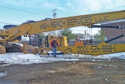
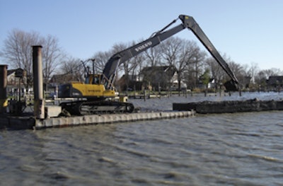
Consider its most recent equipment purchase — a Volvo 290 BLR long-reach excavator. "There is no question that the Volvo excavator is the heart of the dredge operations," says Martin Firth, owner of Lake Services. "We have operated many long-reach machines through their life cycle in the 20 years we have been doing this type of work. Our confidence in the Volvo excavator's capacity and ability, along with the knowledge and support that our dealer, McClung-Logan Equipment Co., offers in supporting this machine, made the decision to select the Volvo 290 BLR an easy choice."
To further enhance the capabilities already offered by the excavator, Lake Services has equipped it specifically to meet the unique demands of working on water.
Adapting to marine life
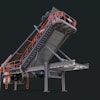
The long-front excavators used by Lake Services are typically mounted on small sectional barges. These barges pin together, and can be transported by truck for added mobility. This flexibility enables the contractor to take on dredging jobs ranging from small lakes and ponds to larger canals and waterways.
Because a number of its jobs involve working on large expanses of water, establishing machine position in relation to the project plans can be a challenge. "When we're out on a channel and it's three miles to the next piece of land, it's quite difficult if you don't have some buoy stakes or some other devices to establish where you are," says Firth.
Firth began investigating GPS-based grade control technology as a means to address this problem. He determined that a Trimble DSM 132 sub-meter differential GPS unit could supply the positioning capability required, but did not offer the desired user interface.
"It does a wonderful job of figuring out where you are, but there's no display or output associated with this device," Firth explains. "It's designed to [transmit] electronically to another device, such as a laptop computer. In our case, I was very concerned about creating a very ruggedized, highly usable operator interface with a good display that was designed to take the environment."
Firth worked with electronics specialist Kevin Morrow of Abaco Electronics to develop a solution. The result was the coupling of the DSM 132 with a Raymarine C80 Multifunction System. "It's a multi-port device that can be used with a combination of [functions], like radar or GPS for depth finders, in marine applications," says Firth. "It's marine electronics — you might find it on a yacht or a big cabin cruiser.
"It's a little bit off the mark," he admits, "but it works."
The weather-resistant Raymarine system includes an 8-in. color monitor mounted inside the excavator cab. The setup also features a Navionics cartographic presentation; Gold series plotter software; and a Raymarine flux compass that provides approximate machine orientation to the operator.
Morrow was responsible for tying the systems together. "He has taken the output from the DSM 132 and [connected it to] the Raymarine display," says Firth. "We checked nine ways 'til Sunday to make sure the various NEMA 183 outputs... would talk to each other. At that point, I had the confidence level to [move ahead with it], and it's come together as a system. It works."
The combined system, along with additional hydraulics, were incorporated into the Volvo 290 BLR in pre-delivery by Morrow and McClung-Logan. Lake Services saw immediate benefits.
"Details of the dredge project, such as the lines delineating the side limits of the proposed dredge channel, are plotted onto the presentation," Firth notes. "The operator can see clearly where the center of his machine is in relation to the work limits to an accuracy of less than 1 meter (39 in.)."
Lake Services is currently using the system for dredging small channels in Baltimore County, near Baltimore, MD. "These channels sometimes go out in open water a mile or more away from any landmark or device that we could use as a positioning device," says Firth.
The operator simply plots the limits of the channel into the system. "If the channel is, say, 50 ft. wide, we plot both sides and each of the turns. Just like a surveyor, we plot all of this information into the device and it puts us on the map," Firth points out. "The channel may be several thousand feet long with several turns in it. And as we work down through there, we can see where we've been and clearly define where we are."
Swimming into place
Using the customized GPS as a guide, the excavator operator is able to accurately maneuver the barge from one position to the next. This is achieved via a specially adapted barge spud operating system linked with the excavator hydraulics.
"A hydraulic excavator normally uses six circuits, but they almost always have a seventh hydraulic circuit that is generally used for a hammer or other device," says Firth. He devised a way to use this circuit to power the large steel pipes, or spuds, that control barge movement.
"The excavator operator can shift the barge location by using a foot pedal to the seventh hydraulic circuit to operate a winch located behind the excavator. This hoists the spud pipes," Firth explains. "The excavator can then swim to the new location using the arm and bucket of the Volvo long-reach excavator, with the differential GPS to guide him."
Once the barge arrives at the desired location, the operator counter-rotates and aligns it as needed using the excavator swing circuit. "The dredge material barges have hardened corners and edges to allow them to be manipulated by the excavator bucket and assist the tug in the landing and sailing of the barges," says Firth.
The spud is then engaged via the excavator foot pedal to hold the new position. "This spud system allows a tremendous amount of flexibility," Firth states. "It's just like working on a tracked excavator and crawling to the [work area]."
In addition, the system reduces the number of workers needed on the barge. "It allows the operator to have complete control without having an extra person on board," says Firth. "Normally, for example, a standard crane spud barge would have a deck winch that has its own engine and its own operator."
And with the GPS system on board, there is no longer any guesswork when moving across open water. "The operator could be sitting out there in the middle of a fog," Firth comments, "and in a matter of seconds he could swim to [the next location], place the spuds down and position himself exactly where he wants to be."
For more information, visit www.ForConstructionPros.com