Closing a runway at an international airport during the summer months — and milling and paving it under tight deadlines so that it can be reopened quickly — can put a lot of stress on a contractor. Barrett Paving Materials Inc.’s Dayton, OH-based Midwest Central Office recently faced just that kind of challenge and brought to bear new automated grading technology that expedited the milling work and kept runway resurfacing on schedule at the Dayton International Airport.
In July 2010, the City of Dayton awarded Barrett a $4.5 million contract to resurface the 1,700-by-150-foot concrete surface of Runway 18-36. Plans also called for an upgrade to the runway’s underdrainage structures, resurfacing of a 40,000-square-foot blast pad located behind the runway with 6 inches of bituminous base material and 2 inches of bituminous surface and construction of 6½ inches of bituminous base topped by 1½ inches of bituminous surface for a taxiway leading to the runway. In addition, Barrett was contracted to excavate and construct a 12-inch crushed aggregate base and 8-inch asphalt overlay on an 87,500-square-foot terminal shoulder and also was awarded a contract to resurface pavement in front of an aviation center where pleasure craft are stored.
Airport runway resurfacing was a new type of project for Barrett’s Midwest Central Office, which had done paving work at the airport but not runways. Also, this project represented the Barrett Midwest Central Office’s first use of three-dimensional machine control. For the most critical part of the job — milling existing concrete surfaces — Barrett turned to a longtime partner on many highway paving projects: Welfle, Inc., Norwalk, OH.
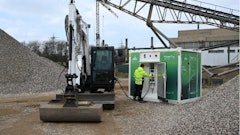
The construction schedule originally called for work to begin in November 2010 around the airport terminal, but temperatures were too low to place silicone joint sealer, noted Nick Meyer, Barrett’s project manager. In mid-May 2011, work began on the east and west shoulders of Runway 18-36. Eight inches of asphalt pavement were milled and 12–14 inches of subgrade were excavated using a Roadtec cold planer to the specified elevation using a high-tech tool that is becoming more common in milling airport pavements.
Combining laser, GNSS
The Topcon Positioning Systems Millimeter GPS+, which made an initial impact in subgrade preparation, increasingly is being used for milling and paving. Just as the system has been used for fine grading, contractors are beginning to use it for “fine milling” — and achieving accuracies within a quarter-inch in contrast to the tenth-of-a foot precision inherent in conventional machine control.
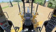
Conventional Global Navigation Satellite System (GNSS) machine control uses satellite signals alone. Such a system uses a rugged antenna mounted to a shock-absorbing, vibration-damping pole along with a GNSS receiver box mounted in a secure location on the machine. Satellites send positioning data to another antenna/receiver combination at a stationary base station. The base station then sends a three-dimensional position and 3-D corrections via radio to the mobile or machine control receiver. Positioning data is also sent to the machine. The stationary base and machine work together to provide real-time kinetic (RTK) position information, revealing the machine’s three-dimensional location on the site. Software compares the machine’s position to the design grade, which was determined using site plans, at a given location. The system also provides visual guidance for machine operators by displaying a site model on an in-cab color monitor, or it automatically adjusts the needed elevation and desired cross-slope of the blade as the operator guides the machine forward.
Millimeter GPS+ combines GNSS and laser. In addition to a GNSS base and rover, the system uses a PZL-1 Lazer Zone transmitter and a PZS-MC machine-control sensor or PZS-1 rover sensor that gets integrated with the contractor’s GNSS receiver. The PZL-1 transmitter sends out a wall of laser light 33 feet tall and up to 2,000 feet in diameter. The contractor can link up to four transmitters for a total reach of 8,000 horizontal feet and 132 vertical feet. The PZL-1 transmitter can operate multiple machines equipped to accept its signals. The GNSS component of the system plots the location of the machine while the laser component guides the grader to position and elevate the blade precisely. The system “knows” the three-dimensional position of the laser transmitter and the three-dimensional position of the machine and is then able to calculate the vertical angle from the laser up to the sensor on the machine and provide a vertical correction.
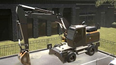
After the project was awarded, Barrett purchased a Millimeter GPS+ system and let Welfle alternately mount the system on the motor grader for fine dirt grading and a Roadtec RX-60 cold planer for milling existing concrete runway surfaces. The cold planer went to work on Runway 81-36 in two phases and proved to be a key factor in keeping the construction team on a tight schedule.
Up and running
In late May 2011, Barrett’s project superintendent, Jay Shawver, watched through fog and drizzle as the cold planer milled the existing concrete surface and conveyed the broken material into a dump truck that crawled along the runway at the same pace. During this first phase, he noted, a 1,000-foot-long section of the runway was closed off. First, one shoulder was excavated and new underdrain was installed. Then, 3½ inches of concrete were milled off of the runway adjacent to the excavated shoulder while excavation work took place on the opposite shoulder. The cold planer then was to mill 5¼ inches off of the taxiway leading to Runway 18-36 but only 4 inches along a joint for an adjacent taxiway, which was not being resurfaced.
The airport had a pavement management study to evaluate all of its pavements. Even though the pavements were determined to be structurally sound, there was another reason why the improvements were needed. A close visual inspection of the existing Runway 18-36 surface revealed why it was time to replace it. “The big issue that the airport has is FOD (foreign object debris) where debris gets into airplane engines and so forth,” Meyer said. “As the concrete ages, it begins to chip and spall.”
Following the closure of the first runway section — for 40 days, according to the schedule — to provide a buffer zone for the still-active intersecting Runway 6L-24R, the remaining 700 feet were to be resurfaced in the same fashion. Runway 6L-24R actually was to be closed in two 10-day phases while the second section of Runway 18-36 was resurfaced.
The entire project was to be completed in 120 days, meaning sometime in August 2011. Meyer noted that rainy weather had caused work delays, including the day before, when a midday thunderstorm made Millimeter GPS+ operation impossible and shut down the jobsite. “With this weather, we’ve already taken hits on our underdrain, so we need to make sure that this production is going great,” he said. Another challenge facing Barrett and Welfle was the tolerance on the milling work: a quarter-inch.
Jeff Combs, president of JC Equipment Sales, Cincinnati, made sure to practically live onsite while the high-profile project was underway. He had sold Barrett the Millimeter GPS+ system, which included a PZL-1; a HiPer Lite+ base station; a 915-MHz RE-S1 spread-spectrum radio repeater set up in the middle of the runway and running off of a pickup truck battery; a PZS-1 rover receiver for Barrett’s grade checker, Jeremy Harper, to use; and an MC-R3 GPS receiver, 9169 control box and 9620 cross-slope sensor for mounting on the cold planer. With the customer using the system for the first time, he wasn’t taking any chances.
Combs recalls doing a great deal of preparation for utilizing the system after selling it to Barrett in late 2010. “Between then and now, we did a lot of preparation for the grade control, making sure the control points would match what was out here,” he said. “That preplanning really paid off for us on this job.
“There was a lot of preplanning on this job—I can’t stress that enough. You have to have it all right and you have the people trained so that when it starts going, it goes off correctly and there are no problems. One thing we’ve learned is that the system works only as well as the control.” With this in mind, Combs suggested that the official surveyor on the project — Luis G. Riancho & Associates, Englewood, OH - set control points every 250 feet. “With those control points in that kind of proximity, we have checks and balances on either side of the machine as we go up the runway.”
Tom Gonzalez, 3D support technician with JC Equipment Sales, set up the PZL-1 and base station alongside the runway. Combs reported that some intermittent problems with radio signals led to his setting up the RE-S1 radio repeater. The system was consistently tracking 18 to 20 satellites, he said. During the previous day’s heavy rains, though, the windows on the PZL-1 kept getting wet, distorting the laser beam. With GNSS-only capability, Shawver decided to shut down operations.
But this was a new day. The cold planer was making two passes on each swath on the runway, first taking off 2½ inches, then a nominal 1½ inches. “The variable depth — that’s one advantage to having this system,” Shawver said. “It’s telling us what to cut and where to cut.” Avoiding overmilling would allow Barrett to minimize asphalt use when it came time to pave the milled areas, Shawver added. “Where we’re milling the concrete, we don’t want to have to come in and do a variable-depth asphalt laye. We just want to be able to do 2½ and an inch and a half to be at finish grade.”
Money-saving results
The Millimeter GPS+ system passed its first test. Riancho verified the elevation of the milled surface on the first 1,000 feet of Runway 18-36 and the entire surface was within tolerance, except for one spot that was 4/100ths high. This was a much better scenario for Barrett than having overmilled. The motor grader also graded the blast pad within tolerances throughout. “What we don’t want to have happen is for [Riancho] to come out and tell us that it’s wrong so that we have to tear it up,” said Meyer. “That impacts material costs, but the system also minimizes any mistakes that could occur, from stringlining to putting markings down.”
Besides the savings on materials, the system also provided savings in surveying costs. Combs pointed out that the cost of having a licensed surveyor constantly checking elevation and grade behind the cold planer would add up fast.