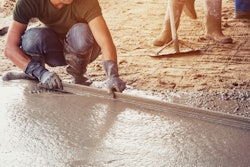
Many early adopters of ground-penetrating radar (GPR) technology found concrete scanning to be the effective application. Those anchoring, saw cutting, or core drilling concrete would hire a contractor to scan the area before cutting to avoid accidentally hitting an object.
For this reason, construction firms have come around to the notion that concrete scanning is vital to jobsite safety and efficiency. In recent years, service companies have also found synergy between concrete scanning and the need to provide utility locating services. Many contractors find GPR to be an important tool that allows them to scale and expand their business while maintaining a high level of service.
Non-destructive Subsurface Survey Technology for Concrete Scanning
Toledo, Ohio-based Ground Penetrating Radar Systems (GPRS) was one of the first companies in the country to focus on concrete scanning, using GPR technology. They determined that GPR was preferable to other non-destructive subsurface survey technologies, including x-raying.
While concrete x-raying remains a valid technique to locate reinforcing steel in certain applications, GPRS found it lacked the flexibility to meet the demands of many projects. The method must be done in conditions in which radioactivity can be safely introduced; it also requires access to the underside of the concrete to be scanned and the job site to be closed.
GPR is used without any radioactive element, instead emitting a pulse of energy into the concrete that bounces off any objects in the slab. When some of that energy returns to the antenna, it creates a signature which clearly shows where and at what depth items within the slab are located. GPRS opted for this more versatile technology, which can be used for both elevated concrete slabs and slab-on-grade applications.
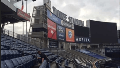
GPRS found that GPR equipment helps contractors safely avoid obstacles in concrete, reducing costly delays and potential injuries. For example, during a recent project to revitalize the upper deck at New York’s Yankee Stadium, the general contractor had to penetrate the concrete floor to work on the ballpark’s protective railings and expected the presence of post-tension cables. If accidentally severed, these high-tension steel strands can snap with enough force to break through the concrete and possibly injure the contractor. Due to the severity of the potential risk and the popularity of Yankee Stadium, X-Ray was impossible for this job.
The Palm XT gives GSSI StructureScan Mini users a handheld miniaturized GPR antenna for enhanced access to tightly spaced areas.
The contractor turned to GPRS, who scanned the area with the GSSI StructureScan Mini XT. This compact tool combined with a GSSI Palm XT antenna, gives operators the ability to cross-polarize for an enhanced level of horizontal and vertical positioning accuracy. Since GPR is entirely safe to use around people, no section of the stadium had to be closed off for other workers, avoiding any major work disruption.
“We would never do a concrete job without GPR,” says Jason Schaff, vice president of sales and marketing at GPRS. “You never really know what’s beneath the surface. GPR lets us provide quantitative data and relevant information to our customers so that they’re able to do their jobs more safely.”
 The Palm XT gives GSSI StructureScan Mini users a handheld miniaturized GPR antenna for enhanced access to tightly spaced areas.GSSI
The GPRS team was also hired by a structural engineering firm to determine the structural reinforcement of a Boston building originally used to manufacture cannons and as an armory. The building featured an 8-in. slab with a 1.5-in. topping slab. Scanning the slab and topping with the SIR 4000 and Palm Antenna, the technicians uncovered a complex circumferential reinforcement design. GPRS provided a mark-out of the location and depth of targets as well as a 3D camera report with a virtual tour to the structural engineering client.
 Mark-out of the location and depth of complex circumferential reinforcement design.GSSI
Along with GPR equipment, GPRS also uses other tools that complement each other, including a reference point locater that gives operators an added certainty that the area they scan on one side of a thick slab corresponds exactly to the same scan on the other side, and an electromagnetic tool that hooks onto a conduit to passively look for something drawing power. To meet the need to locate live power in conduits, GPRS also began providing utility detection services.
Branching into Different Markets
In recent years, GPRS has moved into using GPR for utility location, diversifying its business from 95% concrete scanning in the early 2000’s to now performing 40% concrete scanning and 60% utility scanning. Utility projects range from mapping out an entire facility’s utility plan and providing a detailed AutoCAD file, to examining a small area before installing even a single light pole.
Just like combining GPR with other techniques for concrete scanning, GPR is an integral part of the utility locator’s toolbox. Rodders are used to send traceable lines through pipes to then put a tone on the tracer to assist location. A radio detection tool actively locates pipes under the surface, putting a tone on a tracer and tracing metallic pipes. Magnetometers measure magnetic fields and provide a useful back-up to confirm the location of a cleanout. Other electromagnetic induction equipment serves a similar purpose. GPRS also uses closed-circuit video (CCTV) robots that navigate pipes internally to produce an inside-out visual pipe inspection.
GPR can determine the location of a PVC pipe that does not have a tracer wire, which would have evaded radio detection or discovery by an electromagnetic tool. According to GPRS’s Schaff, “GPR technology really allows us to hone in, be more precise and sets us apart from other service companies that don’t have it.”
GPRS demonstrates the efficacy of their technique when executing a recent contract to locate utilities under parking lots at Target and Walmart locations nationwide. These retailers demanded uniform parking spots to allow customers to quickly pick up online orders. The project had a unique set of challenges because they were not conducting a complete utility location survey of the property to enable them to fully identify all gas, water, sewer, and electrical hazards that lay under the surface.
 Screenshot of GPRS Google Earth overlay used for the Target / Walmart parking lot project.Licensed under CC BY-SA-NC
“When we’re in those parking lots, we don’t have visible meters, tracer wires or cleanouts that we can just find and trace out utilities with,” Schaff says.
Schaff credits GPR units as the tool that locates unknown objects. “If we did not have GPR, we would not be able to properly locate each one of those sections before they run the electrical conduit and put the bollards in.”
GSSI’s visualization allowed GPRS to create drawings with locations and depths of obstacles. Overlaid on Google Earth maps, these detailed references enabled contractors across the country to quickly and safely expedite excavation and construction of these novel parking features.
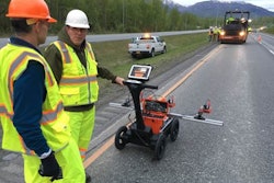
Utility locating also came into play at the Yankee Stadium project, where GPRS had to locate utilities under the sidewalk in front of the stadium before the contractor dug a 125-sq.-ft. trench. For the utility locating portion of the job, GPRS used GSSI’s SIR 4000, with a 400 MHz Antenna. The SIR 4000’s modular design enabled the team to easily configure the system for utility location.
Ground-penetrating radar allows GPRS to scale both halves of business nationwide.
“Because our business has two different verticals with concrete scanning and utility location, we want to use an equipment company that has the ability to cross over and do both,” Schaff says.
In 2019 alone, GPRS completed 70,000 individual projects in nearly 60 markets with an overall accuracy rate of 99.5%.
“We use GSSI GPR for every one of those markets and every one of those jobs,” he says.
Cross-training is Key to Quality
GPRS has adopted a strategy of developing new markets with limited personnel by cross-training its personnel. All GPRS project managers undergo a three-month training process to ensure a repeatable methodology so each customer gets the same level of service.
The strategy is furthered by the availability of systems small enough to transport in the trunk of a sedan, and capable of quickly determining the reinforcement of concrete (hollow core, rebar, post-tension cables, metal decking) or adjusting to soil makeup at a utility location site with ease.
To ensure quality across the company, GPRS instituted an intensive training program and developed a specification, Subsurface Investigation Methodology (SIM), that lays out requirements for training, equipment, and process. In addition, GPRS has partnered with GSSI for their GPR equipment to ensure they’re using professional-quality equipment.
“GSSI has been at the forefront, developing new technologies,” says Schaff. “They know what they’re doing, and we know what we’re doing. It makes total sense to pair with the manufacturer that fits us so well.”
The Future of GPR Services
Historically, nearly 80% of GPRS’ business is either repeat or referral. The company focuses on long-term performance, recognizing that repeatable accuracy is at the core of their services. By effectively leveraging the flexibility and precision of GPR technology, GPRS has diversified and expanded its business from regional to nationwide, without diminishing service quality. To continue to build on its success, the company has acquired four GPR service provider companies to better meet customer needs and prepare for market growth.
About the Author
Jami Harmon is the marketing operations manager for Geophysical Survey Systems, Inc (GSSI), a leader in ground penetrating radar. Harmon has been with GSSI for 12 years and has experience with ground penetrating radar in the utility locating, concrete inspection, transportation infrastructure, archaeology and geophysics markets. Harmon is an active board member and committee chair for the Concrete Sawing and Drilling Association (CSDA) and participates in several industry associations.