SUNNYVALE, Calif., Sept. 13 /PRNewswire/ -- Trimble (Nasdaq: TRMB) introduced today the new Trimble® Juno(TM) SD hand-held, an addition to the pocket-sized Juno series of durable, lightweight field computing devices with integrated Global Positioning System (GPS) technology.
All Juno series models include integrated GPS, wireless LAN (Wi-Fi) and Bluetooth® connectivity, a 3 Megapixel camera, a 533 MHz processor, 128 MB of onboard memory, a MicroSD/SDHC memory card slot, an all-day battery and a 3.5 inch display. The Juno SD hand-held builds on this core functionality with the addition of integrated 3.5G High-Speed Downlink Packet Access (HSDPA) cellular SMS and voice capability.
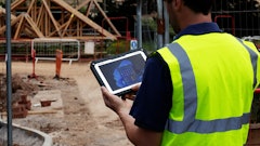
Using the data transmission capabilities of the Juno SD hand-held, mobile workers can access information in the field such as work-orders, map data, reference files, emails, and Internet resources without making a trip to the office. Mobile workers can also update mission critical information in real time that can lead to increased overall data accuracy and productivity. In addition, users can now keep in contact using the new cellular voice capabilities, enabling users to call the office for the next job, provide live updates from the field, or make a call in case of an emergency. As a result, the Juno SD hand-held eliminates the need to carry a separate mobile phone.
"The Juno SD hand-held is the ideal integrated solution for GIS-enabled organizations that require high productivity from their mobile field workforce. It keeps them connected and in touch while removing the need for a separate camera, GPS data collector, PDA, and cellular phone," said Peter Large, general manager of Trimble's Mapping & GIS Division. "All Juno series handhelds incorporate a high-sensitivity GPS receiver specifically designed to maximize position yields in challenging GPS environments, such as under forest canopy and near buildings in urban areas. Incorporating modem and voice capabilities into the Juno SD hand-held transforms the device into a true enterprise field workforce productivity tool."
Users can achieve 2 to 5 meter GPS positioning accuracy in real-time with Satellite Based Augmentation Systems (SBAS) such as the U.S. Wide Area Augmentation System (WAAS), European Geostationary Navigation Overlay System (EGNOS), and Japan's Multi-Functional Satellite Augmentation System (MSAS). When higher accuracy is required to meet company or regulatory standards, field data collected with Juno series hand-helds can be post-processed with office software such as Trimble GPS Pathfinder Office(TM) or Trimble GPS Analyst(TM) ESRI extension that includes Trimble DeltaPhase(TM) technology to achieve 1 to 3 meter accuracy.
A range of optional accessories are available for the Juno series hand-helds. The OtterBox Defender Series case provides additional protection through a hi-impact hard polycarbonate shell wrapped in a silicone skin for absorbing bumps and shocks. The vehicle mount, in conjunction with Trimble TerraSync(TM) field software and navigation software such as ALK's CoPilot Professional, provides a complete and productive in-car navigation and data collection solution.
The Juno SD hand-held is available in 10 languages for worldwide users and is fully compatible with Trimble's range of Mapping & GIS field and office software. Powered by Microsoft® Windows Mobile® operating system, Juno users have access to personal productivity tools such as Word Mobile, Excel Mobile, Internet Explorer Mobile, and Outlook® Mobile, allowing a seamless exchange of data between the field and office.
The entire Juno series, including the new Juno SD hand-held, are available now through Trimble's Mapping & GIS authorized distribution channel.
About Trimble
Trimble applies technology to make field and mobile workers in businesses and government significantly more productive. Solutions are focused on applications requiring position or location--including surveying, construction, agriculture, fleet and asset management, public safety and mapping. In addition to utilizing positioning technologies, such as GPS, lasers and optics, Trimble solutions may include software content specific to the needs of the user. Wireless technologies are utilized to deliver the solution to the user and to ensure a tight coupling of the field and the back office. Founded in 1978, Trimble is headquartered in Sunnyvale, Calif.
For more information, visit: www.trimble.com.