The most congested freight-intensive stretch of road in the U.S. is the intersection of I-290 and I-90/I-94 in Chicago, followed closely by New Jersey and Houston intersections.
The American Transportation Research Institute (ATRI) and the Federal Highway Administration (FHWA) Office of Freight Management and Operations are monitoring freight significant highways as part of the Freight Performance Measures (FPM) initiative. A central aspect of these monitoring activities is the identification and quantification of major chokepoints and bottlenecks along highways that are critical to the nation's freight transportation system.
The following 250 highway location profiles offer state and local governments, as well as private sector stakeholders, information on congestion trends and conditions for infrastructure that is vital to freight transportation. Although the majority of the locations monitored through this effort are urban interstate interchanges, the roadway designs represented within the 250 profiles are quite diverse, and no two highway locations are identical.
Though each location that is monitored is unique, it is typical that freight traveling across urban interstate interchanges is affected to the greatest degree by AM and PM peak-period congestion. There are, however, several locations where congestion influences freight mobility during all hours of the day. Additionally, several of the monitored locations will or have seen significant changes in performance due to influences such as long-term highway construction, which can often cause decreases in performance. Finally, there are locations that are monitored as part of this assessment where congestion is not currently an issue.
This annual report ranks congestion's impact on freight by producing a "congestion index" through analyses that use customized software tools and terabytes of data derived from trucking operations. More specifically, this effort utilizes GPS technology and information to understand the impact of traffic congestion on truck-based freight. The index figures produced in this report represent truck travel during weekdays in 2010, at all hours of the day; average speeds below a free flow of 55 mph are considered to be an indication of congestion. The profiles are listed in rank order; Location 1 which is near downtown Chicago has the highest congestion index (and therefore has the highest level of congestion that significantly impacts trucking using this methodology). A detailed analysis, which includes hourly speed profiles, is available for each location analyzed.
This type of information is useful to private and public sector freight stakeholders that wish to better understand the severity of congestion and mobility constraints experienced along the highway transportation system. For the public sector, a measurement of freight significant congestion can allow for better-informed decision making related to transportation infrastructure investment. The private sector can use this type of information to avoid or anticipate congestion and to develop long-term routing and distribution strategies.
The list of 250 locations monitored through this program focuses on freight significant highway infrastructure and includes many of the most congested bottlenecks in the United States. The monitored locations have been identified over several years through reviews of past research, surveys of private and public sector stakeholders and through the use of available highway speed and volume related datasets. If you would like to recommend a location for the program to monitor that is not on the current list, please click here and submit your suggestion.
For a description of the research methodology, please click here.
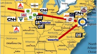
The 10 Most Congested U.S. Roads
(Click on links for detailed reports on each location)
- Chicago, IL: I-290 at I-90/I-94
- Fort Lee, NJ: I-95 at SR 4
- Houston, TX: I-45 at US 59
- Houston, TX: I-10 at I-45
- Houston, TX: I-10 at US 59
- Gary, IN: I-65 at I-80
- Austin, TX: I-35
- Chicago, IL: I-90 at I-94 (North)
- Atlanta, GA: I-285 at I-85 (North)
- Los Angeles, CA: SR 60 at SR 57