
We all know that one pothole-ridden roadway in our neighborhood that we try to avoid at all costs. Your local municipality, however, may not even know that street has any issues that need to be addressed. Because of this, cities are looking for ways to direct their street improvement resources more effectively given the limited resources to monitor streets and lack of funding for repairs.
Cities are starting to invest in digital monitoring to replace traditional labor-intensive techniques, enabling more frequent and accurate assessment of infrastructure quality. These digital methods primarily fall into one of two categories: vehicle-based monitoring systems, which collect data via an array of sensors attached to a vehicle (usually very expensive and owned or contracted by the city), and smartphone-based monitoring systems, which leverage built-in smartphone functionality to gather road data.
Vehicle-based Monitoring
Vehicle-based monitoring systems outfit vehicles with a variety of sensors to continually track the path they travel and provide a profile of the street conditions encountered, creating more consistent and objective data than is collected in traditional road surveys.
The problem is that this equipment can cost over $50,000 per vehicle, a cost most municipalities can’t justify given that they can’t even afford to repair the roads they monitor.
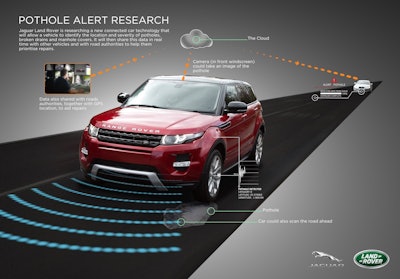
Automakers Hate Potholes Too
Besides ruining your driving experience, potholes are also responsible for many accidents and costly repair bills. This is why automakers are even starting to get into the pothole monitoring game.
Today, research vehicles at Land Rover are being installed with technology that allows them to identify the location and severity of potholes and broken manhole covers and subsequently adjust the suspension in milliseconds. Researchers working on the technology say it will be possible to share this data with other cars via the cloud so all drivers will get a warning about dangerous potholes, allowing them to slow down and avoid the danger, which means the potential for punctures, wheel and vehicle damage as well as road accidents will be reduced. The system would also alert road authorities about the potholes.
Crowdsharing Data via Smartphones
While in-vehicle based monitoring may be a few years in the future for most of us, drivers today likely already have one piece of equipment in their vehicles that can keep track of potholes - their smartphone.
Other cities and researchers have experimented with monitoring street quality using the built-in GPS, camera and accelerometer functionality of smartphones. These monitoring systems are ideally placed on city vehicles that already travel the city daily (such as public works trucks), or used to assess street quality through crowdsourcing, much like Waze’s traffic monitoring.
In a 2015 pilot, Carnegie Mellon researcher Christoph Mertz partnered with the city’s Public Works Department to install smartphone cameras in city vehicles to capture images of the streets in Pittsburgh, PA. Paired with GPS data and fed through a computer algorithm, these images are classified according to the types of road surfaces and the damages pictured, something the city hopes will help them identify sections of street that need the most urgent attention.
Similarly, Canadian startup TotalPave provides cities with a smartphone app that records overall road quality (measured via the phone’s accelerometer) and manually tracks individual issues, such as potholes. Initial findings report that the smartphone data is within 10% of the International Roughness Index (IRI) numbers reported by expensive vehicle monitoring systems.
TotalPave, which costs cities little more than a smartphone, plans to start with 38 cities and expand from there, eventually targeting more than 13,000 North American cities.
When used in vehicles on daily routes around a city, apps like these can collect a wealth of data while requiring minimal time or effort from city employees and can eliminate many single-purpose street survey efforts. However, the idea of crowdsourcing street quality data from citizens holds the potential to create an even larger, richer dataset.
Boston – in recent years, a frequent early adopter of civic technologies – launched Street Bump in 2012. Pioneered by the city’s innovation office, New Urban Mechanics, this free app is Boston’s take on smartphone-based street monitoring and is open-source, so other cities can use and improve it.
By aggregating the experiences of hundreds or thousands of drivers who traverse the streets of a city, technologists and city officials hope to uncover insights about road quality which would otherwise require intense labor from city workers. With dozens of phones reporting poor conditions on a road each day, these once-hidden problems become readily visible to city officials and can be prioritized for repair.


![Lee Boy Facility 2025 17 Use[16]](https://img.forconstructionpros.com/mindful/acbm/workspaces/default/uploads/2025/09/leeboy-facility-2025-17-use16.AbONDzEzbV.jpg?ar=16%3A9&auto=format%2Ccompress&dpr=2&fit=crop&h=135&q=70&w=240)


