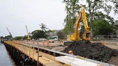
The cost of a single hit to an electric or gas line will more than pay for having your own locating system on your truck or trailer. That's not to say that contacting One Call before you dig or otherwise excavate isn't necessary or effective, because it is. But so, too, is a little added precaution and protection for your employees.
"Supplementing One-Call location of buried utilities is often necessary to estimate utility depth and locate utilities outside the utility right-of-way," says John Bieberdorf, senior product manager - Electronics at the Ditch Witch organization. "It is also necessary to search for abandoned or unknown utilities." Manufacturers offer a variety of locating systems to help pinpoint potential subsurface obstructions. Different systems are employed to accommodate different soil conditions and utilities.
An electromagnetic search
If all underground utilities were constructed of the same material, locating them would be relatively easy. Unfortunately, they're not. Pipes can be made of metallic or nonmetallic materials and, as Beiberdorf points out, even conductive cables and pipes can be constructed of copper, aluminum, iron and steel.
For locating metallic utilities, most private locators, in-house locating crews and One-Call locators rely on systems that actively produce electromagnetic or radio frequency signals, which are purposely coupled to underground utilities. The choice of signal frequency is an important factor for effectively tracing and identifying buried underground utilities, and no single frequency covers all conditions.
Bieberdorf advises users to select the lowest frequency required to locate the target to minimize coupling into unwanted lines. He offers the following rules of thumb for setting frequencies:
Low frequencies (60 Hz to 1 kHz) -- These are useful for line tracing and identification over long distances. They don't couple easily to adjacent lines, but do lie within power band frequency harmonics interference, which can cause problems.
Medium frequencies (1 kHz to 30 kHz) -- The most versatile of signals, they are high enough for induction, lie outside the power frequency interference band and have limited coupling to adjacent lines.
Higher frequencies (30 kHz to 100 kHz) -- Easily induced onto most lines, they can be very useful for an initial site scan/search. High-frequency signals travel quite nicely on cable. However, they are also more easily coupled to adjacent lines, and are less suitable for long distances than lower frequencies.
Very high frequencies (above 100 kHz) -- These frequencies are easily induced onto objects, but can also couple very easily to adjacent lines. They are best used to induce signals onto difficult-to-couple lines in dry, low-conductivity, sandy soils.
Multi-frequency locators provide the best of all worlds. "A multi-frequency system such as the Ditch Witch 910 Series allows operators to tune the frequency they're putting into the ground to the type of line or pipe they are trying to locate," says Beiberdorf. "The 910 series is a build-to-your-own needs system. It can be configured with one or multiple frequencies specific to the needs of individual users. The product is lightweight and designed to be operated around the construction work site."
A receiver or locator is used to pinpoint the location of underground utilities. "Using a lower frequency reduces the chances that it will jump from the target you're trying to locate to another one nearby," Beiberdorf indicates. "If it is desirable to locate all underground utilities, a higher frequency that lights up virtually everything underground would be appropriate."
Bear in mind that such receivers are calibrated under ideal test conditions to ensure optimal performance and accuracy. Less than ideal field conditions may cause signal distortions or contain noise distortions that can, in turn, distort location or depth readings.
Advancing technologies
Software advancements are among important changes that Matt Manning, McLaughlin locator specialist, has seen in his 20 years of industry experience.
"Basic components have been in place for years," he notes, "but software enhancements have allowed electromagnetic units to filter out interference and improve locating accuracy. Being able to connect locators to GPS has also facilitated utility mapping. Years ago, utility location was often pinpointed by surface reference points. If those references were moved or lost entirely, so went the utility location. Nowadays, GPS affords instant mapping by longitude and latitude, something that doesn't change over time."
McLaughlin's Verifier G2 and Vision FLX feature four active frequencies and three passive frequencies. In both modes, users have the capacity to obtain important depth information.
The units have two screens -- a combination peak, null screen and a peak-only screen -- and offer both active and passive locating capability. According to Manning, "Users actively locate utilities by controlling the signal -- by broadcasting and receiving a specific frequency. When passively locating a utility line or cable, the user is not controlling the signal."
He gives this example: "Direct connecting a transmitter to a surface water valve and sending a signal through the line to a receiver is actively locating where the line runs. Going out with a receiver only, set at 60 Hz, is one way to passively locate a hot power line."
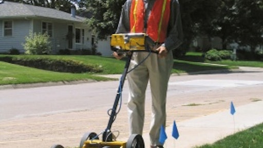
Ground Penetrating Radar
Ground Penetrating Radar (GPR) units give operators the ability to identify both metallic and non-metallic utilities such as PVC pipe and concrete culverts. Instead of inducing a signal on a utility line, these systems send microwaves through the soil to locate targets.
"GPR systems respond to the electrical contrast between two different materials and display reflected amplitude," explains Keith Sjostrom, Vermeer's senior project engineer. Fortunately, you don't have to be a geophysicist to operate one. "We like to say that the guys operating the shovel can use the Interragator EZ. It's as simple and easy as pushing a button and moving the unit along the survey path."
Designed primarily for trenching companies or those doing excavation work, Vermeer's GPR features a control unit and a 400-MHz antenna situated on a small, four-wheel cart. A lithium-ion battery provides 2 1/2 hours of run time.
Sjostrom emphasizes how easy it is to use. "If the default values match site conditions, all users have to do is turn on the unit and start collecting data," he asserts. Once crossing utilities are located, the user will likely survey either side of the utility and also perform a perpendicular survey. "A backup cursor allows users to mark a hyperbola (utility location) immediately and accurately.
"Soil conditions play an important role in GPR performance," he continues. "Dry, sandy soil is ideal, whereas the conductive properties of clay soil contribute to less than ideal conditions. If operators are unsure about the makeup of the soil, they can depth calibrate the GPR unit electronically or by locating a known target and entering its depth."
It's not a matter of having either an electromagnetic locator or a GPR locator, says Matt Wolf, president, Mala Geoscience USA. Realistically, contractors or anyone in the locating business should have both. The two systems complement one another.
Mala GeoScience's GPR unit can be used for spot locating, or integrated with GPS for onboard mapping. The latter, Wolf states, is a feature especially attractive to subsurface utility engineers who map out utilities prior to the design and construction of large building projects. "Over the last few years, this mapping function on GPR units alone has likely saved utility companies billions of dollars associated with the cost of relocating utility lines," he relates.
Wolf agrees that operating a GPR unit is relatively simple, although users need to be properly trained to identify important vs. unimportant subsurface items. "Users are seeing reflective energy -- the downside of which means they are seeing everything from the target to virtually anything nearby," he points out. "Performing parallel and perpendicular surveys and knowing what to look for will help ensure accurate identification of a utility line or cable. Once the line or object is located, its location can be marked with a hand-held spray can or sited electronically with the GPS mapping system."
Return on investment
Electromagnetic locators can cost anywhere between $3,000 to $5,000, depending on the model. Their GPR counterparts can tally upwards of $10,000 to $20,000 and higher, also depending on the models and how they are equipped.
Does the return on investment justify the expense? The manufacturers cited certainly think so. And so do contractors who -- by using one or both of the systems -- minimize the risk of cutting through an expensive communications cable or, worse yet, severing a power or gas line that can seriously injure or kill a worker.
It's all about location, location, location. Contacting One Call is imperative. But backing it up with another locating system, or two, provides added insurance for your company and employees.