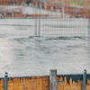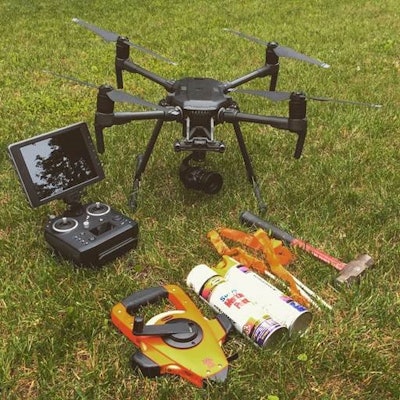
Surveyors are harnessing the power of drone technology by focusing on at-risk riparian areas of northern New Jersey. In fact, images captured by unmanned aerial vehicles (UAV) have become part of the documentation for a Federal Emergency Management Agency (FEMA) program that saves Pompton Lakes residents hundreds of thousands of dollars per year on flood insurance premiums.
 Images captured by unmanned aerial vehicles (UAV) have become part of the documentation for a Federal Emergency Management Agency (FEMA) program.Dresdner Robin
Greg Gloor, Dresdner Robin survey director,volunteered on a project to assess Pompton Lakes’ flood-prone waterways. Gloor flew 11 individual flights over the rivers, 215 ft. above the water level. The UAV moved at 10 mph, using a 15-mm fixed-zoom lens to capture 60-ft. sections of the terrain. Images were snapped every two seconds (1,042 total) and were later analyzed to locate obstructions in the river channel. The photos aided a stream cleaning project that is part of the borough’s flood mitigation program.
Cutting Flood Insurance Costs
The UAV-collected data was also submitted as part of Pompton Lakes’ application to FEMA’s Community Rating System (CRS) program. Waterway assessment is a key component of the CRS program, and active participation saves the borough’s residents over $300,000 on flood insurance premiums. Outside of cost benefits, the UAV program also saved the borough’s volunteers hundreds of hours of “first-hand” analysis time, according to Erik DeLine, Pompton Lakes Councilman.
DeLine adds that the drones “produced stunningly clear imagery, which enabled us to fully understand and prioritize which hazards needed to be cleared, providing an invaluable service to our residents.”
“Assisting a borough that houses three rivers – which can pose a threat to homes and other structures – is rewarding," says Gloor. "Historically, the flood threat can be quite active here, but this emerging technology helps mitigate it.”
The image-capture project offers a feasible way to spot obstructions, Gloor continues, and the visuals help facilitate FEMA’s CRS program, spurring immediate financial benefits.
Monitoring Rising Waters
Gloor’s work has helped expand similar waterway assessments in the state, including the Ramapo River in Oakland, NJ. There, both video and still photography – which includes the adjacent tributaries – is used to assess river conditions for restorative work with the state. The drone imagery enables the Borough of Pompton Lakes to identify and prioritize potential flood hazards that need to be cleared. (Pequannock River)Dresdner Robin
As flooding continues to plague areas of northern New Jersey, especially following a particularly wet 2018, surveyors anticipate the need for survey and data acquisition of river corridors to rise.
“These river channels present unique challenges for access and safety,” Gloor says. “Dresdner Robin has been utilizing the capabilities of UAV to provide critical data on river conditions to flood-prone communities in North Jersey.”