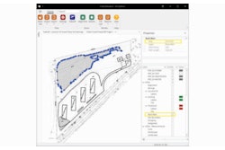
InSite Elevation Pro users can export KMZ files to third-party mapping applications like Google Earth, Map Plus and other geo-browsers with jobsite data. Original PDF or CAD file data can be overlaid with cut and fill contours, subgrades, stripping regions or area and length take-off before export.
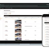
This information is accessible on a desktop app in the office to verify proper location and planning, as well as on a GPS-enabled smartphone or tablet.
With InSite Elevation Pro, users can send the aligned KMZ file to a mobile device. As users walk on the jobsite, the location is pinpointed on any of the original site plans with cut and fill contours displayed. This enables individuals to walk right to the location of a structure, building corner, driveway, etc. and share the information in real-time.
The KMZ file can be shared with several individuals working on a project, including: GCs, subcontractors, engineers, inspectors and suppliers.