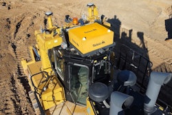
Flying drones for reality capture in constrained spaces is challenging, but a new firmware update from Leica Geosystems, part of Hexagon, for its Leica BLK2FLY delivers powerful indoor scanning capabilities.
The update enhances collision avoidance and other capabilities of the drone, and comes at no cost to existing BLKFLY users.
3D reality capture of building exteriors and interiors is necessary to create complete digital twins, and supports construction quality control and other core business functions. The BLK2FLY’s new indoor scanning capability expands users’ abilities with an enhanced the autonomous UAV scanning system to allow for safe, effective indoor navigation and capturing. This capability also expands the BLK2FLY’s ability to capture various environments outdoors, but it is indoors where many of the enhanced navigation abilities that let the UAV function without a GNSS comes into their own. Hexagon has leveraged its visual simultaneous location and mapping (SLAM) system to give the UAV real-time spherical imaging for enhanced spatial awareness.
“We can fly without GNSS because the BLK2FLY uses lidar not just for scanning, but for navigation,” Business Director for Autonomous Reality Capture Pascal Strupler, of Hexagon’s Geosystems division, said. The UAV has a complement of five cameras, and only two had previously been used for navigation. Now, data from four of the cameras can inform navigation systems. As scanning commences, the BLK2FLY builds up an internal map of its environment.
Early Adopters Push Limits with BLK2FLY
In an early September 2023 briefing with IRONPROS, Strupler mentioned early adopters have been using the enhanced product since early 2022.
“What was interesting was that we saw a range of use cases we didn’t anticipate,” Strupler said. “We saw it being used everywhere you want to scan complex structures efficiently where it doesn’t work from the ground. In a number of settings, we saw reality capture customers complement their portfolio of terrestrial scanners with an aerial scanner.”
The SLAM element of the product is significant because mapping happens during the scan, which means users can see the results in real time instead of waiting to export data from the UAV.
“Scanning is faster in general, but you already have a preview of what you scan during the flight,” Strupler said. “You can see if you are missing something, and what the coverage looks like. Otherwise, you don’t know if it works well. You could miss half of data and construction continues in the meantime.”
Capturing as-builts and deviation detection are the primary use cases across the board, according to Strupler.
“We are seeing the same use cases as our terrestrial scanners, but on bigger interiors that are not captured that well with terrestrial scanners,” Strupler said. “We can scan the current set up of the truss system on the ceiling. A terrestrial scanner is not enough if you have a 40-meter-high ceiling. With BLK2FLY, you can just fly up there around the ceiling. Photogrammetry fails because there are so many small elements photogrammetry will just meld together.”
Other use cases have included indoor stockpile measurements.
“This works the same as outdoor drones used to measure stockpiles, but in this case, you can often not walk around stockpile,” Strupler said.
The BLK2FLY has also seen interest from industrial engineering and construction companies performing refits or rebuilds.
“People are saying they would like to scan their machinery hall to get the current state,” Strupler said.
Robust Software Estate
BLK2FLY users can send data to Reality Cloud, powered by HxDR, Hexagon’s cloud application for processing including register, mesh and 3D model creation. But Hexagon’s capabilities to extend value of point clouds from the BLK2FLY go well beyond registration.
In June of 2022, Hexagon launched its Hexagon Digital Reality Platform, Reality Cloud Studio, a software-as-a-service (SaaS) application where BLK2FLY users can upload reality capture data for automated processing and creation of photorealistic digital twins. This data can be securely shared with other stakeholders for real-time project collaboration including immersive visualizations.
“We have a direct upload link from the device,” Strupler said. “Right after scanning, users can log into their account on a laptop, and while that is being done, they can continue scanning. After data is uploaded, processing starts automatically. The software will register the data together so several scans of a location with be put together automatically.”
Buyers can according to Strupler bundle the BLK2FLY purchase with a subscription to Hexagon’s register product family. Reality Cloud Studio is sold through self-service subscriptions online. Subscription levels range from the low tens of dollars per month to over $100 per month per user.
The BLK2FLY UAV runs $60,000, which Strupler said is competitive with many terrestrial laser scanners. It is available directly through Leica or value-added resellers.