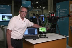
The Leica Aibot Unmanned Aerial Vehicle (UAV) system is based on DJI’s aerial platform, the M600 Pro, and can be used to rapidly and autonomously acquire mobile 3D mapping data.
- Allows users to process and analyze millions of data points gathered from above and visualize the data to provide actionable information
- Data can be combined with existing survey technologies such as TPS, GPS and laser scanning to provide a more complete set of information
- High-definition imagery and 3D mapping allow for the viewing of site mapping or progress documentation
- Supports sharing of data to Cylcone and Cloudworx
- Integration of the UAV point cloud with terrestrial scan data enables users to make informed decisions
- Leica Geosystems software suite supports the new UAV workflows
Fill out the form below to request more information about Leica Aibot Unmanned Aerial Vehicle System