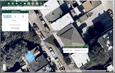
Nearmap, a location content provider specializing in high-resolution, aerial imagery, has helped increase the number of paving projects Lindy Paving conducts each season by providing high-resolution aerial imagery for its new field data collection app. The new map-based app helps lower expenses while increasing revenue.
Developed by Lindy Paving’s Kyle Monceaux, field engineer, and Steve van Vliet, senior IT business analyst, the field app is browser-based and designed to increase efficiencies in communication and project management of its 400-plus paving projects conducted each season.
Created for both field and office use, the browser app replaces reams of paper maps, spreadsheets and PDF files, while allowing planners and estimators to prepare for projects without physically going to the site.
“We needed a simple, mobile map to relay project progress and provide communications between Lindy field staff, estimators, project managers and executives,” says Monceaux. “It also helps provide the planning information we need for next year’s projects.”
Lindy’s custom app shows active and archived projects on a map merged with Nearmap aerial imagery that can be zoomed in and out as needed by the user. For example, one of their clients – a large utility company – works with Lindy to repave roads and sidewalks of the hundreds of infrastructure repair locations they work on each year.
The aerial images show Lindy crews the exact locations of their projects. “It makes it very easy for us to look and see where our projects are located for planning and execution purposes,” says Monceaux.
Lindy Paving, Inc. is the largest asphalt paving contractor in Pennsylvania. Based in New Galilee, PA, Lindy has consistently delivered award-winning asphalt paving and product manufacturing.
Nearmap's aerial imagery allows all the players to come to the table through the app. In future versions of the app, van Vliet plans to build in tools allowing calculations and drawing directly on the Nearmap imagery to determine exactly where things will go on any given project, which will help in developing estimates.
Lindy built the storage and retrieval system using SQL, ArcSDE, ArcGIS Server, Amazon S3 media storage, and aerial map services provided by Nearmap.
Lindy Paving’s field data collection app is proving to be a big hit among the company's project managers, estimators, and planners by providing:
- Better planning and estimates - Nearmap aerial imagery allows Lindy to view new projects and better plan without onsite visits, resulting in cost savings and faster estimates.
- More efficient crew management - The Nearmap imagery allows crews to see the project site before they physically go there. It does not require a lot of clicks and steps to get to the information they need.
- Pre- and Post-Construction information - Nearmap within the app provides all the key data points and a whole view of the project lifecycle. Visibility and access to all key data points allows Lindy to better plan and prioritize projects, which leads to increased projects and revenue.
- Reduced Staffing - The increased effectiveness of all parties involved has eliminated the need to add additional staff to manage the more than 400 projects completed in a single paving season.
“We are grateful for our partnership with Lindy Paving,” says Patrick Quigley, senior vice president and general manager, North America at Nearmap. “They are utilizing Nearmap aerial imagery in a unique way to improve their business processes and strengthen their bottom line. This type of innovation allows Lindy Paving to make informed decisions rapidly. They plan and deploy resources in a highly efficiently manner.”


![Fcp Racatac Chair 10893876[1]](https://img.forconstructionpros.com/mindful/acbm/workspaces/default/uploads/2025/10/fcp-racatac-chair-108938761.10l0At5WXv.png?ar=16%3A9&auto=format%2Ccompress&bg=fff&dpr=2&fill-color=fff&fit=fill&h=135&q=70&w=240)


