SmartDirt RTK app turns Apple or Android phones or tablets into high-accuracy GPS/GNSS receivers for on-site grade checking, drone/UAV ground control point (GCP) set out and site data collection.
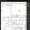
- Allows users to know where they are in relation to plan sheets, cut/fill maps, satellite images and street maps
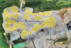
- Can determine the volume of a stockpile, find the daylight line between cut and fill and calculate balanced regions in the field
- Records site details with RTK accuracy and uses the camera on mobile devices to record site progress
- Provides a simple process to set out GCPs and reference drone/UAV flights to site coordinates
- Allows users to view drone/UAV orthomosaic images in the field and measure against updated progress surfaces
- Transforms the GPS in mobile devices from accuracies of within several feet to accuracies within a tenth of a foot for survey-grade measurements
- Antenna connected to a reference network with position calculated directly in state plane coordinates, meaning no need for a base station
- Supports Apple and Android devices when paired with a compatible RTK antenna
Fill out the form below to request more information about AGTEK SmartDirt RTK Turns Smart Phones or Tablets into High-accuracy GPS/GNSS Receivers