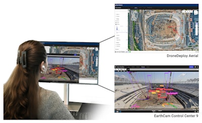
EarthCam and DroneDeploy have released a new software integration that unifies live jobsite video with aerial reality capture data. Available now, the integration links EarthCam’s Control Center with the DroneDeploy platform, giving construction managers a single interface to view live streams, time-lapse video, orthomosaic maps and 360-degree site documentation.
The system is designed to provide a more complete picture of jobsite activity by eliminating the need to switch between separate platforms for ground-level and aerial views. It enables a two-way data flow, allowing DroneDeploy’s aerial data to sync automatically within EarthCam’s Control Center, while EarthCam’s live streams and panoramas are accessible inside the DroneDeploy interface.
This consolidation of visual data helps streamline project oversight and progress tracking. By combining continuous live monitoring with detailed aerial imagery, teams can improve documentation, detect issues earlier and enhance safety and security monitoring. The integration features a simplified setup process to help users quickly combine their visual data streams.
The new feature is now live and available to current customers of both companies.


