It often goes unacknowledged that construction was one of the earliest data-focused industries. Understanding measurements of the worksite, material quantities and progress has been core to projects as old as the Roman Coliseum and as new as the Navi Mumbai International Airport currently under construction. What’s changed is the way we gather and use the data and fortunately, we’ve gotten much better at it.
Here’s one way to think about it: data is there whether we take it or not. It’s the extra earth sitting on site that wasn’t included in the pre-bid survey, it’s the pile of materials waiting to be used that turns out to be short, and it’s the foundation that was laid just inches off spec. Gathering this data simply gives contractors a heads up to these unforeseen challenges so we can manage them as early as possible, before they become more expensive, time-intensive problems. On today’s construction sites, lack of project data costs businesses more than $177B annually.
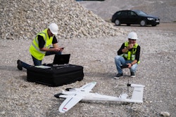
Traditional Surveying Versus Drone Surveying
Notably, it’s not just the action of gathering the data that’s feeding into these huge costs. So much of the data gathered on worksites today through techniques like traditional surveying includes delays or discrepancies that allow problems to go unrecognized for too long. Surveys executed through traditional methods often contradict one another or come in weeks after a critical decision was made, unaided by the relevant information gathered during the survey.
Drones have emerged as a solution to these issues and are facilitating more real-time, accurate survey data. They are especially efficient for large site surveying for projects like highways and airports that are highly time intensive to have an individual walk around and gather survey measurements manually. Drone surveys are also contributing to more visual site communication by providing assets like 3D site maps created through photogrammetry that can give every team and contractor the same view of the site and an indisputable source of truth from which to make decisions.
D.H. Griffin Infrastructure, a division of D.H. Griffin that provides site grading and development, specialty concrete and underground utility services in North Carolina was seeking to get a clearer look into their sites to bid more accurately. The estimation department needed a more reliable, precise, and easy to implement source of truth after they experienced issues approximating the scope of new jobs.
“We had run into some problems where we bid a project and found out there was more or less dirt than we anticipated,” said Keith Taylor, the survey manager.
They knew a drone program could solve these problems but needed to ensure indisputable accuracy and quick data turnaround. Accordingly, the firm leveraged Propeller’s smart ground control points, which guaranteed their drones could lock images to exact coordinates, enabling accuracy within 1/10th foot or better. Drone data processing times also typically beat traditional surveying methods but vary across providers who offer the service. For guaranteed fast processing, D.H. Griffin went with Propeller, which ensures deliverables within 24 hours and has 98% of surveys processed in just 12 hours.
By incorporating the drone program, D.H. Griffin has been able to address their estimation issues, to more accurately approximate project costs and timelines. In one instance regarding a landfill project, Keith was able to identify an issue that could have led to delays and additional machine costs.
“Early on in this project, they were doing truck counts,” Taylor said. “After I flew my first drone flight, they found out their measurements were wrong. There was too much fluff in there, they hadn’t accounted for it. They were off by 15% in each truck.”
They’ve also gained a competitive advantage when bidding on new projects, especially when negotiating change orders. After all, it’s hard to argue with a picture and GPS data.
Making Data Count
Drone surveying isn’t the only new data-producing technology available on the worksite worth consideration. Especially today as so many new technologies and software are being brought to market, it’s very easy to go from having a useful amount of data to drowning in it. To differentiate solutions that will return ROI from those that will simply feed you more numbers, consider these points:
Data analytics that drive the most ROI across project phases and departments are those that are shareable and comprehensible for more than one team, and those that are actionable and readily available.
The point of having good data on hand is to improve decision-making and ultimately reduce project timelines and costs. Solutions that provide highly complex data that only a few technically trained individuals can interpret are prone to creating bottlenecks, with everyone waiting on one individual to interpret the data they need to move forward. Visual data such as maps, charts and dashboards are comprehensible to all, improving its usefulness and shareability as a single source of truth.
The most impactful data analytics are those that are actionable and can save teams from days or weeks of rework on an error by noticing a small piece of data early on. For this reason, it’s so important to consider the data turnaround time when evaluating new analytics solutions. Data that comes in after the big decisions have already been made are more likely to drive frustration than fixes.
Prioritizing Data for Proactive Intervention
On the ideal worksite of the future, contractors will have access to near real-time data on every inch of dirt, machine locations, materials stockpiles and more. This deeper understanding of the hour-to-hour current state of the site will mean problems can be addressed before they even take form, and projects can stay on budget and on timeline.
The data already exists, we must simply be ready and willing to capture it.
Written by John Frost, vice president of business development at Propeller Aero. Learn more about the company at https://www.propelleraero.com/.