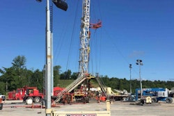
At its Waypoint 2023 Annual Summit June 8, construction photogrammetry leader OpenSpace announced it was extending the insights from its reality capture solution deeper into the construction enterprise with tools that extend it deeper into building information modeling (BIM).
In March, Openspace rolled out mobile app feature BIM Compare, which enables field workers to easily navigate and view their model side-by-side with actual site conditions. But at Waypoint, they announced OpenSpace BIM+, a microsuite of BIM features to extend their OpenSpace Capture product for:
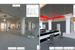
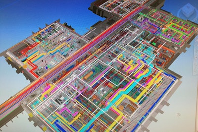
- BIM analysis tools that drive insights by overlaying BIM, 360° photos and point cloud data
- BIM coordination tools that make OpenSpace Capture's popular field note feature an integral part of BIM workflows enabling streamlined workflows facilitated by OpenSpace’s new partner Revizto, Navisworks or BIM Track
- Model management tools to improve revision control which is crucial when plan revisions overlap with the construction timeline thanks to Autodesk model import, support for multiple models, and model usage reporting
OpenSpace BIM+ also exports to BCF and improves the user experience for field users by caching BIM data on the device as a hedge against poor connectivity.
OpenSpace FLIR Integration
In a move that brings new use cases for both construction and facilities management, OpenSpace now also offers an integration with thermal imaging and infrared imaging camera leader FLIR.
“Infrared cameras see heat emanating from the world,” OpenSpace Vice President of Product Neel Sheth said, citing use cases like electrical contractors scanning a panel to ensure overload bodies are overheating due to incorrect specifications, or identifying leaks behind walls or around windows during commissioning.
“What is even more exciting is these types of cameras are becoming a lot more accessible, so more teams can find issues and correct them more quickly,” Sheth said.
Flexibility In the Field
OpenSpace also announced the launch of customizable tags so a construction team can use notes more aggressively to track activity or productivity in the field. This increased flexibility to support interactions between the field and front office starts to make it look like OpenSpace could wind up interacting with or notching out some usage for field productivity software products like Sage Field Operations, Assignar, Raken and others—if primarily in vertical construction environments. These products serve to connect work packages defined in project management software to crews, workers and equipment and then capture and report on productivity, ultimately to drive application for payment.
In the IRONPROS multivendor marketplace, construction field productivity software is one of the most active sectors. In the 2023 State of the Industry Construction Technology Report, almost 20% of respondents were planning or budgeting for field productivity management software and another 34% were already using it. Construction photogrammetry software, the category OpenSpace falls into most directly, sees 32% of respondents planning or budgeting for an expenditure and 26% already using the technology. Based on what Sheth and OpenSpace Director of Product, OS Capture & Growth Richard Acton-Maher said about the OpenSpace product direction on a call before the announcement, as integrations get these two types of construction software products to talk to speak the same language, they will have more and more to say to each other thanks to this new flexibility.
 IRONPROS Senior Technology Editor Charles Rathmann catches up with OpenSpace Director of Product, OS Capture & Growth Richard Acton-Maher.Dean Pele
A Rapid Pace of Innovation
Apart from BIM Compare and innovations announced at WayPoint, OpenSpace rolled out capture heatmap functionality to identify which areas of the jobsite have been previously captured and which areas have been missed to ensure an entire site is documented and QuickConnect, which speeds the handshake between cameras and the mobile app.
But OpenSpace is visibly making investments in a trend IRONPROS has been following—convergence of multiple reality capture methods into a single version of the truth as point clouds, 360 images, thermal imaging and BIM come together on a single pane of glass.
“Absolutely, there's going to be convergence,” Acton-Maher said. “We started, obviously, from the standpoint of capturing what has been done on site. And then we started to move towards the middle through defect detection and defect tracking, which is what Fieldnotes was originally used for. But we've already started to get a further towards tracking not just defects but progress on site. We allow for manual progress tracking, or at least manually verified progress tracking so you can see what our AI says about progress but then also look and verify it has been done. Next, we're starting to look at progress tracking against the BIM model, so that you can get a better sense not just of a defect in what's been built, but what's left to build. And so that gets you closer to the other side of the spectrum. I think there is a continuum from manual progress tracking and automated progress tracking against the BIM.”
READ THE IRONPROS OPENSPACE PRODUCT DEEP DIVE