In the construction industry – where total spending has exceeded $2 billion as of March 2024 – pre-project property assessments and operational scalability are of paramount importance. Opportunities to utilize cost-saving software or redistribute labor more resourcefully are welcomed with open arms by project managers facing critical logistics decisions.
Powered by recent advancements in technology, aerial imagery changes traditional property assessment approaches. Concurrently, the advent of 3D and oblique mapping has exponentially increased the level of detail in remote evaluations, enabling on-site operations to scale while also increasing efficiency and reducing costs. Furthermore, access to actionable data helps developers understand the unique risks associated with construction zones and enables teams to implement precautionary measures to safeguard structures and infrastructure while enhancing the area's sustainability and value.
Leveraging the tech-enabled tools at their disposal and equipping teams with data-driven insights will lead construction firms to more precise evaluations of property and ultimately drive safer and smarter commercial investments.
Understanding Aerial Imagery and Location Intelligence Technology
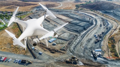
Aerial imagery and location intelligence technology are transformative geospatial mapping tools that are only continuing to advance. They work by capturing images through aerial cameras that fly at various altitudes for visualizations from a bird’s eye view, capturing images via planes, drones or satellites and layering them with artificial intelligence (AI) to deliver location and land intelligence. Each vehicle for capture often provides a different type of value for developers.
To be certain, distinct project needs call for different approaches to securing imagery. Fixed-wing aircrafts (i.e. planes and drones) can attain images with significantly higher clarity and precision than those provided by satellites, which are more effective for broad captures over larger areas. While drones are better suited for zoomed-in captures of an individual building, they are vulnerable to weather interference and are further disadvantaged when prospecting requires proximity to restricted “no fly” zones, such as those surrounding airports. In addition, drones are expensive to commission and do not scale effectively for projects that cover larger areas. A key challenge for construction teams is striking the balance between images more comprehensive and scalable than drone footage while providing insights more precise than satellite imagery.
For construction and engineering projects, the ideal location intelligence lies in leveraging frequently updated aerial imagery captured by planes flown at lower altitudes. When they are equipped with high-resolution, ultramodern cameras, this is the most information-rich and cost-effective method of providing an in-depth visualization of any target location. This improves both early building site selection as well as the more intricate project decisions.
To further up-level the value of aerial photography, AI can be layered on to synthesize and identify pertinent land insights. AI can be programmed to extract features like tree overhang, tall vegetation, ground surfaces and miscellaneous debris. This advanced data can be analyzed and interpreted according to the specific needs of the user, providing construction teams with a key advantage that can prove extremely valuable in objective decision making.
As these innovative technologies and geospatial mapping tools continue to evolve and improve, we can anticipate even more efficient and accurate methods of land analysis and visualization in the years to come.
 Aerial imagery and location intelligence technology are transformative geospatial mapping tools that are only continuing to advance.@Rich - adobe.stock.com
The Role in Property Assessments
Compared to “boots on the ground” surveying, aerial imagery actively and autonomously upgrades the workflow for construction teams, freeing them from tedious, repetitive tasks. Detailed maps and models can be digitally distributed among stakeholders, thereby minimizing the need for frequent site visits—which can cause construction costs to spike.
Professionals in architecture, construction, and engineering face escalating costs for on-site visits. The US Department of Labor estimates the average annual salary of a construction site worker to be $39,520 with vehicle running costs of $0.67/mile. Assuming such a worker makes one site visit per day with an hour of travel time to the site, the business would have spent $14,673 in a year on site visits—and that is just for one worker. When the amount of people working on a construction project is considered, construction companies can significantly streamline workflows and reduce inefficiencies through virtual construction site visits, enabled by aerial imagery and location intelligence.
During a virtual site visit, construction project managers and stakeholders are empowered to apply 3D and oblique aerial imagery models for the measurement of length, width, height, area, and radius of a building, vegetation, power poles and a litany of additional infrastructure assets – encompassing the full array of ground features on site. The provision of access to these directional perspectives, in addition to vertical imagery, greatly simplifies remote measurement and significantly enhances analysis.
These assorted aerial images can be seamlessly integrated into premier geographic information systems (GIS) and computer-aided design (CAD) platforms, fostering continued visualization and evaluation of properties and sites. This ensures users receive the most accurate and precise location data, thereby optimizing the quality of the information at their disposal.
Reaping the Benefits of Accuracy and Precision
Aerial imagery tools not only offer scalability and more detailed information, but also provide firms with a competitive edge when building project proposals and winning bids. Project roadmaps that are backed by the most up-to-date and accurate data will invariably enhance the understanding and buy-in for all stakeholders.
From a sustainability standpoint, project managers can utilize aerial imagery to monitor for prevailing environmental conditions. Such imagery provides insight into how prospective projects might affect adjacent lands, potentially disrupting pathways, wetlands, or areas susceptible to erosion among other ecological variables. The integration of location intelligence tools allows builders to preserve the environment throughout the construction and infrastructure development phase.
These enhanced insights can significantly improve not only the pre-project property assessments, but crucially impact the subsequential structure development, as well. This is especially true in regions that are susceptible to natural catastrophes or extreme weather events. For instance, they can help identify wildfire, flood, earthquake, and other natural disaster risks to allow for proactive mitigation.
When developers understand the risks associated with the areas they're building in, they can take proactive steps to protect structures, infrastructure assets, and adjacent land, making the area both more sustainable and increasing its value.
By potentially saving millions in rebuilding costs, project managers get a leg up on the competition with the ability to demonstrate – via insights backed by data – a commitment to mitigating property damage.
As the construction industry grows to accommodate the ever-expanding U.S. infrastructure, aerial imagery and location intelligence play the pivotal role of a veritable source of information. Utilizing the technology available in hyper-localized location intelligence can equip construction firms with the tools that deliver the highest level of insight for optimal project logistics and accurate commercial investments.


