HCSS, a provider of software that helps heavy civil construction businesses streamline their operations, introduced a new version of HCSS Aerial, a drone-based data analytics platform.
This upgrade is the sixth release of the software since the product was launched in March 2020, and incorporated direct customer feedback.
This new version of HCSS Aerial contains design visualization and digital inspection enhancements.
 HCSS
HCSS
"Every week, our customers are flying their drones and processing thousands of images across multiple sites. They are finding new ways to leverage this technology across the project life cycle,” says JP Giometti, HCSS executive director, global strategy and corporate development. “As we integrate HCSS Aerial data with other HCSS products, and we add our proven customer support and professional services capabilities, we are building a unique heavy-civil data analytics platform that will bring automation and insights to the industry for better decision making.”
Learn more about the technology:
The new release of HCSS Aerial includes:
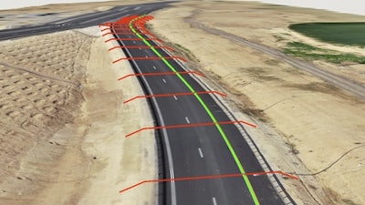
- Design visualization enhancements: The look and feel of the 2D designs on the models are enhanced. HCSS Aerial now displays designs on the model as 2D clamped to the ground.
- Image duplication detection and validations: The upload wizard now helps you achieve even more accurate models by validating that the uploaded image set doesn’t contain duplicates. This feature doesn’t only check for duplicated image names but analyzes location data and time of capture for superior detection. The upload wizard also warns you of images that do not have complete GPS information. These alerts help you avoid re-processing models, save valuable time, and, most importantly, get the most accurate results.
- Enforced checkpoint marking: To improve accuracy reports, Ground Control Points cannot be set as a checkpoint if it is not marked on at least two different images.
- Auto-georeferencing supporting real-time kinematic (RTK) flights: HCSS Aerial's unique auto-georeferencing models now support RTK flights.
- Import and support of native design files: HCSS Aerial supports all leading design file formats - DXF, DWG, DGN, and LandXML - for progress monitoring analytics and design overlay visualization for quality assurance. With HCSS Aerial, contractors do not need to have CAD experts, conversion tools, or data quality checks. Upload native design files and start your work.
HCSSA Aerial is also in the process of beta testing a new feature for digital inspections and automated grade checking that transforms 2D designs into digital data model objects, calculates grade checking reports, and further automates progress monitoring. This entirely digital process significantly reduces work, prevents human error and ends the construction companies' dependence on several software tools to perform these frequent reports.