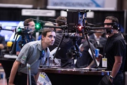
About 4,000 drone professionals from across a number of industries packed into Caesar’s Forum in Las Vegas last week for the Commercial UAV Expo.
This is a new record number of registrants according to the expo staff, and an indicator that the unmanned aerial vehicle (UAV) or drone market is maturing and growing in size, market applicability and sophistication.
The drones themselves were center stage and on Tuesday, Sept. 6, several hundred attendees sat in record 115-degree heat for outdoor flying demonstrations featuring:
- Ascent AeroSystems’ Spirit, which boasts an all-weather frame so it can operate in rain, snow, sleet or even a sandstorm
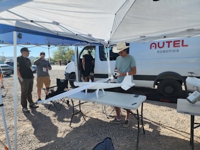
- Autel Robotics’ Dragonfish Standard and Dragonfish Lite with their tilt-rotor and waterproof design and AI tracking capabilities
- Commaris’s Seeker—a long endurance and high speed fixed-wing craft which showed off its range, loitering persistence and near silent noise profile
- Frontier Precision and Yellowscan performed a LiDAR Demo, integrated with the Freefly AltaX UAV platform
- Skydio focused its demonstration on autonomy, which the company claims makes drones a more reliable resource by addressing the constrained supply of trained and credentialed drone pilots
- Skyfront demoed its Perimeter 8 hybrid-electric UAS, designed for large-scale surveying projects
- WingtraOne’s GEN II, which includes predictive maintenance features for solid reliability
 Frontier Precision demoed its FreeFly AltaX equipped with Yellowscan LIDAR.Charles Rathmann
New Construction Drone Tech
Drone and hardware manufacturers also made significant announcements during the event, and while these new developments may not find a market in construction right away, they illustrate trends contractors ought to keep in mind as they plan and manage their own drone programs.
Matternet, for instance, announced that their M2 drone has become the first unmanned non-military aircraft to achieve Type Certification from the Federal Aviation Administration (FAA). While Matternet focuses on delivery rather than construction applications, the successful completion of the four-year FAA evaluation signals the agency may greenlight additional use cases like operation beyond line of sight, beyond limited exemptions that facilitate some more advanced drone operations.
Read the IronPros Product Deep Dive on Propeller Aero
Flir Teledyne launched SIRAS, a drone that includes a quick-connect dual radiometric thermal and visible camera payload. The drone is compatible with Pix4D software, and post-processing software from Clear Thermal Studio. Flir Teledyne created this product in part due to a hole created in the market by government entities backing away from market leader DJI due to concern about data potentially being compromised by the Chinese government and the company's placement by the U.S. Treasury Department on the Non-SDN Chinese Military-Industrial Complex Companies List. The Blue UAS list created by the Defense Innovation Unit outlines drone hardware approved for military use, and the State of Florida Department of Management Services has issued a similar list of approved drone manufacturers, requiring government agencies to transition to these approved drones by January 1, 2023. Construction contractors doing work for government entities, therefore, may consider moving towards a fleet compliant with the Blue UAS list as it could become either a hard requirement or a perceived advantage when pursuing government contracts.
Apart from domestic manufacture, the SIRAS has no cloud, cellular or Wi-Fi connection to the internet, and there is no dedicated online cloud service the drone communicates with, as is often the case with DJI drones. Contractors doing work for government entities, therefore, may also want to consider how accessible a drone is to the public internet as well as the location of servers used for drone data post-processing.
Teledyne Flir Vice President of Product Management. Industrial Technologies Mike Walters said the drone would initially be marketed to the first responder and inspection markets.
“Maybe the most interesting thing for contractors would be the 20-megapixel mapping mode that we have—using a vision-based camera—that can get them good telemetry data," Walters said. "Thermal would help spot leaks depending on whether whatever in that pipeline is hotter or colder than the surrounding air. The thermal camera will also tell you if part of your electrical infrastructure is overeating and is good for solar panel inspections to isolate cells that are not performing.”
One piece of drone functionality with strong application for construction is a camera that can not only rotate from landscape to portrait mode, but also adjust the way data is captured to deliver a narrower total field of vision. This can be useful for contractors working on linear assets like highways or pipelines. This is not a feature of the new SIRAS drone, but is common on others including several models from DJI. Paired with supporting software, many drones can shift from shooting photogrammetry images in portrait to landscape mode to increase data capture speed on linear assets like roads, transmission lines and pipelines while reducing the number of images and related post-processing time.
Another exhibitor, AgEagle Aerial Systems, offers lightweight fixed-wing craft and software that can capture in vertical mode and adjust the mission to use this feature. The company has expanded through acquisition and organic development well beyond agriculture, the industry that gave it its name. The company in 2021 acquired senseFly and its eBee line of drones and sensor manufacturer MicaSense.
Today, AgEagle has a substantial footprint in the construction industry and new tech including their SODA 3D mapping application.
“SODA stands for sensor-optimized drone application,” AgEagle North American Regional Manager Gary Licquia said. “The camera tilts on a gimbal to capture three images for even more vertical data. The drone can scan 1,200 acres on a battery charge.”
 Draganfly Innovations at the Commercial UAV Expo 2022.Charles Rathmann
A Consolidated Approach to Virtual Data Capture
Drones in construction are primarily data capture devices, and data capture is coming to job site through other avenues as well. One shift that was palpable at the Commercial UAV Expo was data from multiple sources—including drones and ground-based scanning technologies, are being united in the same model, digital twin or geographic information system (GIS).
One example of how this is affecting drone technology is construction drone software vendor PropellerAero’s new DirtMate product.
DirtMate is a survey-grade GPS receiver that does not fly on a drone but rather rests on earthmoving machines and produces elevations, measuring and capturing the elevation and using the ribbon to build a 3D model of the project with hourly and daily quantities. DirtMate does not control the blade making the cut, but does record the elevation. It is simpler and more affordable than 3D grade control technologies from Trimble, Leica or Topcon. It is non-competitive enough that it is being sold by Trimble’s SiTech dealers and can be afforded by most small contractors.
“There are a lot of telematics solutions that will give you operating data and some information on where an asset is from a broad standpoint,” Propeller Aero Co-Founder and CEO Rory San Miguel said in an IronPros Product Deep Dive, stressing that DirtMate will prioritize capturing and presenting data in a simple and useful way. “We are trying to get centimeter-level data off each machine. We are working hard to eliminate the data indigestion, because contractors need data that is very actionable. We are constantly iterating on how we can present the data. Earthmoving operations are usually tracking progress on a weekly basis. We think there are opportunities to automate the data capture and turn up the frequency of reporting.”
 Propeller Aero AeroPoints.Propeller Aero
Another SaaS company, JP Global Digital, markets JP Interactive Viewer, which
manages LIDAR point cloud data for surveying, construction, inspection, and other
applications and centralizes them with BIM and 360-degree images. JP Global Digital's
representatives participated in the event to identify drone hardware vendors to partner
with so their offering can capture and provide insight from multiple data sources.
“We are offering three reality capture views in a single web-based application,” JP
Global Digital Solutions Engineer Valentin Malave said. “We are looking for partnership
opportunities with more organizations for drone data capture and marrying that with
terrestrial-based image capture and simultaneous location and mapping (SLAM) LIDAR
data. Nobody else is doing this. It will enhance collaboration between teams both as
they are gathering data in the field, as data is ingested by engineers or architects, and
as data is viewed in meetings with owners.”