Version 5.0 of the Seeker acquisition software automates several key capabilities to help assure greater accuracy.
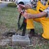
US Radar Inc. has enhanced its ground-penetrating radar (GPR) systems with a major upgrade of its global-positioning system (GPS) software module and the integration of Garmin GPS technology.
- GPS software incorporates a split-screen view that can simultaneously display real-time radar-mapped imagery of the jobsite alongside the user’s choice of maps
- Maps available from public sources such as Google Earth or OpenStreetMap, or from proprietary mapping sources including site plans or as-built plans
- Split-screen capability provides an enhanced, real-time context for plotting and analyzing subsurface data
- Operators can combine radar and map data and export it into AutoCAD or ArcGIS software while on the jobsite
- Garmin GPS antenna integrated with the company's antenna on the Quantum Imager and Q5C GPR models
- Version 5.0 of the Seeker acquisition software helps assure accuracy by automating various settings such as gain control, recognizing the GPR system’s antenna and configuring antenna-specific settings
Fill out the form below to request more information about US Radar Enhances GPR Systems with GPS Software, Integrated Garmin GPS Technology