Construction is back, but many of its workers aren’t. In April, total job openings in the construction industry hit 440,000 — the highest number recorded by the Bureau of Labor Statistics in more than two decades. That number is down to 375,000 in a BLS recent report, though the building industry is still struggling to fill an historic gap between the number of jobs available and the number of people willing to take them. News reports have relayed anecdotes of builders hiring more women and paying high school students top dollar. Both ultimately may be good things, but there is another, more sustainable solution: developing new technologies that, in some cases, can do a job better and more safely than any human worker ever could.
Learning technology is particularly important in industries like construction, where experience often matters more than education. Building and development sites require rigorous planning, and even then they can be fraught with safety hazards due to unknown factors. Exhaustive surveilling can be cost-prohibitive, as can teaching an army of new workers the ropes, both in terms of money and time. Without sufficient training or experience, human workers can easily incur physical costs, as well. What’s needed now are tools that can not only do the job, but make planning more efficient, effective, and safe. Thankfully, those technologies, which we know familiarly as machine learning (ML) and artificial intelligence (AI), already exist. The hard part is evolving from the theoretical world to the building site. Project planning is an obvious place to start.
3D Rendering and Property Tours
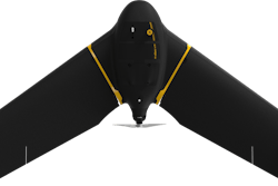
When drones first appeared for sale and use in the private sector, the construction industry quickly understood that the technology was far more than a mere toy. Early adopters included realtors, architects, city planners, and builders. An aerial drone, controlled from the ground, could capture any property from any angle in high-definition photographs and/or video. Since then, drone capabilities have grown exponentially. Think of a modern drone as a flying rack onto which you can attach or swap the latest technologies — multispectral sensors, high-definition cameras, and machine learning software capable of creating 3D maps from topographical data, able to be captured from virtually anywhere.
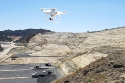
Drones can also both monitor and measure land for planning large-scale development. As more information is collected and analyzed, the software can figure out the best and most efficient courses of action for the task at hand. But using ML also means that site data can seamlessly interact with data from outside sources, such as architects and engineers. In effect, the software and the human experts are learning and planning together, and in real time. Even better, as the drone learns its territory from multiple passes, it can create more efficient routes and charge itself, limiting or even eliminating their downtime. Drones can also be employed to perform critical tasks that used to require humans and vehicles, such as locating the precise locations of utility lines and potential physical hazards.
Mark the Market
Covid has made drones even more important to the construction industry. In 2021, a record amount of land was purchased for commercial development. This, combined with a persistent housing shortage in the United States, has inspired major investors — from private equity giant Blackstone to Amazon founder Jeff Bezos — to enter the homebuilding market. This implies a record amount of planning work, albeit without a record number of human workers.
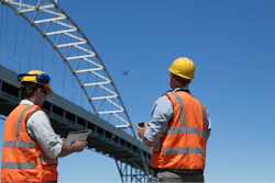
As the suburbs stretch out into the exurbs, and while Covid has made more remote locales desirable for millions, the travel time alone required to surveil building sites has become staggering. Whether building somewhere with existing infrastructure or starting from scratch, GPS-, AI- and ML-equipped drones are already being hailed as the industry’s newest heroes. Why? By using drones and sophisticated software, planners can combine, match, and overlay their own data vis-a-vis terrain and property lines.
Third-party software can then do much of the grunt work, taking advantage of existing data and resources, utilizing these most efficiently while avoiding pitfalls. For existing structures, including those that will service a main property and may be impractical to relocate — such as utility boxes, transformers, and switching stations — drones’ ability to measure heights and depths accurately has proven essential. These measurements help field technicians make better decisions during the planning stages, as well as after the development is complete. In the future, planning software should be able to plug into municipalities’ databases to “learn” about local environment regulations and codes. This will ensure that future developments are in compliance from the early stages, avoiding expensive and/or contentious changes later on.
Precision
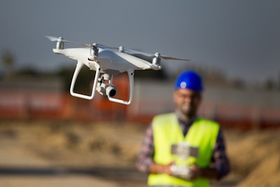
Of course, builders have more than the labor shortage to worry about these days. With supply chains stressed, lead times are longer and materials are more expensive, making cost savings opportunities in other areas, like planning, more important than ever. Planners need tools that can not only work quickly, but accurately, and they need experience. Human surveyors are limited by time and accessibility issues, but aerial drones can capture high-quality images in a remarkably short period of time thanks to both their speed and their ability to work essentially around the clock. This saves on human capital, allowing multiple projects to progress simultaneously, and promises to rebalance the cost-benefit proposition that has been rocked by supply chain disruptions, Covid, and war.
Post-Construction
Every new development eventually becomes much more than surface, gradations, and materials. Each property is unique, and even with the best planning, builders need tools to assess and adjust their creations as needed. Drones can now be equipped with embedded multispectral sensors capable of monitoring and measuring things like thermal heat, lighting, and depth. These are important elements before, during, and after development; and the more accurate information, the less guesswork and expensive change orders or redos builders need to worry about. I consider integrated sensor capabilities to be drone technology’s “killer app,” as they allow developers to substantially reduce overhead costs when managing properties.
These sensors are also invaluable when repairing and maintaining industrial structures, including towering buildings, manufacturing plants, and power grids — not just because they learn, but because they never forget. This brings us to the last essential planning technology: the cloud. Unlike humans taking notes, data collected by machines is processed and made available in real time. Data can not only be shared with planners, but with other stakeholders such as insurance companies, contractors, utilities, and even the media. I like to think of these drone-driven planning systems as shared maps that are driving future advances in AI and ML while benefiting from them enormously. Drones are allowing us to do planning in real time, rather than make plans that may or may not see the light of day. As President Dwight Eisenhower, the father of our federal highways, once observed, “Plans are nothing, but planning is everything.”