Site Scan is a complete solution incorporating the drone, mobile application with autonomous flight modes and web application for processing drone photos into 2D maps and 3D models, overlaying blueprints, performing measurements and enterprise success services
- Hardware independent and works with both 3DR and DJI drones, including the Phantom 4 Pro and DJI M200 series
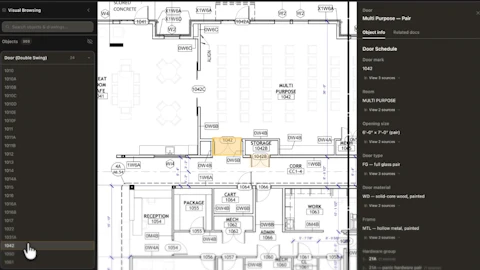
- Users can export data products into Autodesk-native file formats so it works seamlessly with tools such as Civil 3D, Revit and more
- Enterprise platform makes it easy to scale drone operations across the enterprise and securely share data with key stakeholders
Fill out the form below to request more information about 3D Robotics Site Scan Drone Data Platform


![[VIDEO] 3DR Solo Drone with Site Scan Autodesk Workflow](https://img.forconstructionpros.com/files/base/acbm/fcp/image/2016/03/default.56ddda837c644.png?auto=format%2Ccompress&fit=crop&h=167&q=70&w=250)