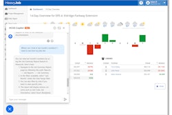
This version of the HCSS Aerial cloud-based solution for continuous monitoring of infrastructure construction projects adds more features to make jobsite mapping and data visualization easier and more effective.
- Provides survey-grade accuracy levels of 1/10 ft. from independent checkpoints across small and large survey areas
- Enhanced Accuracy Report and Checkpoints Support validates model accuracy, providing detailed information listing checkpoints' and GCPs' information, residuals and errors
- Includes Local Coordinate System Support for geo-referencing and seamless workflow integration and Terrain Filtering capabilities for more accurate volumetric measurements
- Image Validation used to check integrity of images selected for uploading and look for gaps
- Transforms large numbers of images into accurate point clouds, DSMs and orthomosaics
- Can be used to track execution progress with the ability to compare "digital twin" models of the jobsite from different dates and against the design
- Site documentation and reports generated in 24 hours
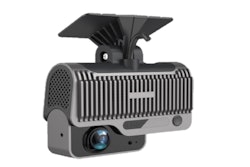
- Works with the latest generation of drones for professional applications
Fill out the form below to request more information about HCSS Aerial Drone-Based Data Analytics Platform