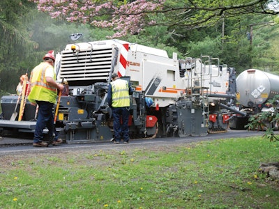
This spring and summer, we’ve talked a lot about asphalt paving plans, equipment and technology to identify opportunities to safely increase production. As I talk with contractors, operators and Department of Transportation (DOT) officials, we consider which technology solutions may be the best for this on-season as we look down the road at what may happen in the next season. As many asphalt paving crews are heating up their pavers and rollers, more and more people are keeping a close eye on compaction data.
In some states, like California, compaction data — especially for hot mix asphalt (HMA) projects adhering to intelligent compaction (IC) — must be reported to CALTRANS (the state’s DOT). Several states have required compaction data for a few years now, so it's not just HMA pavers relying on advanced sensors to record real-time data for quality control officials and contractors’ review. During IC, DOT officials and contractors work together to improve pavement quality through uniform density.
 RDO Equipment Co.
Equipment Technology Used During IC
Watch Ryan Zenahlik, senior paving application specialist at Topcon Positioning Systems, as he details the ins and outs at World of Asphalt 2025.
And it’s not just CALTRANS; Colorado's DOT and many others not only require compaction data, but also density minimums and a post-paving resurfacing schedule if damage occurs to the roadway within a set period of time after project completion. One Colorado contractor mentioned that on one of his projects, the DOT required that 100% of the project’s lots pass density specifications in order for any incentive to be paid.
There are many variables when it comes to paving smooth roads: weather conditions, soil density and type of mix. All these factors — even before the equipment or technology — affect the ability to achieve proper compaction for smooth roads with great ride quality.
There are three key factors that contribute to quality compaction:
- Mat temperature
- Mat depth or thickness
- Compactor rolling pattern
Each state’s DOT will specify in their compaction requirements and various bonus opportunities if the core sample of the road achieves 100% compaction. Even if the state or county hasn’t specified density requirements, it’s on the horizon. Plus, crews embracing IC reduce over-compaction risk and passes. With several technology solutions from manufacturers, contractors can do the following:
Maintain a record of the paver and roller’s continuous location, number of passes and stiffness value
Regularly conduct surveys, and test and sample asphalt to ensure it meets DOT standards
Create and share IC quality reports
WIRTGEN GROUP or VÖGELE equipment from the factory floor integrates with John Deere Operations Center, a fleet management system that has many applications besides GPS monitoring.
Even contractors working on projects without specific density requirements say using machine monitoring data and road surveys to deliver IC reports usually results in receiving maximum payouts from their clients. Asphalt contractors I’ve talked with say IC helps their crews coordinate each part of the process: production, transport, paving and compaction.
“I remember working with one Minnesota contractor who figured out they weren't receiving incentives because of slight changes in rolling patterns,” said Cody Wagner, paving technology product manager at RDO Equipment Co. “They leveraged data recorded from their HAMM roller to take corrective action and maximize their incentives.”
Wagner explains that in states like California and Minnesota, DOT officials also want to review temperature data when the mix is laid. When DOTs receive this thermal data, they can ensure that a road may last for many years to come. (Remember from one of my previous columns when we realized that the ultimate beneficiary of smooth roads? It’s all of us who use these roads.)
Let’s take a closer look at the equipment and technology innovations to automate road scans and road design.
Your Digital Map? Topcon’s RD-M2 and Virtual Ski
Recent enhancements in lidar scanners with Global Navigation Satellite System (GNSS) receivers allow contractors to collect more data with even in low-connectivity areas due its high-powered processors. Topcon’s RD-M2 attaches to the back of a truck or milling machine to quickly collect precise survey data.
“The RD-M2 is a more compact and wireless solution that takes less time to get up and running in my experience with contractors,” Wagner said. “Its high-powered processor, the RD-M2, captures more data points including any micro slopes that can automatically be fed into a CAD system.”
Inside the RD-M1 and RD-M2
Watch this episode of The Track to discover the differences between RD-M1 and RD-M2 and see large point cloud data translating into an effective paving plan.
After the RD-M2 collects precise surface data using LiDAR, it gets fed into Topcon’s MC-Max system to set an asphalt paver’s screed height, width and steering. A paver’s screed height or steeper angle can result in more pre-compaction before the roller passes. When the paver’s screed is set to the right height, it can reduce air bubbles during the first passes. Rob Andrew, RDO’s construction technology specialist level three based in Montana, explains that while Topcon’s P32 systems use physical, direct control of the screed based on grade and slope references, the latest Virtual Ski uses digital data to control the screed.
 Topcon GNSS receiverRDO Equipment Co.
“On rural or county roads where there are fewer fixed GNSS points, a Virtual Ski can enhance the paver’s accuracy,” Andrew said. “The Virtual Ski can be set 13 feet to 330 feet off the planned road.”
The Virtual Ski plus 3D-MC milling software replaces analog screed control systems like Multiplex-Ski, Big Ski or Sonic Ski models. Crews even have used the Virtual Ski to survey sharp curves to set screed height and slopes for those winding mountain roads.
A dealer can offer 2D or 3D technology systems including sensors and GPS to control a paver's screed height that works with many different asphalt paver models. Crews say that they feel like they can design their paving path in real-time with these LiDAR, machine control and computer-aided modeling tools.
Your Cruise Control? Hamm’s Smart Compact Pro
Besides weather and asphalt mix, HAMM rollers’ mode types — vibrating (VV), oscillation (VO), combination (VT) or pneumatic-tire (TT) — will change its compaction force. Different materials and tasks will require different modes. For example, the VV mode set to a high frequency is best for deep compaction, while VO mode is best for final smoothing passes.
To help operators understand which mode and frequency are accurate for each pass, HAMM developed wireless scanning solutions to automate real-time density compaction. HAMM’s Smart Compact Pro integrates real-time density measurement into its automated compaction process. The Smart Compact Pro measures the dielectric conductivity of the asphalt mix to be compacted, forming a correlation with the mix’s current density and air pockets.
“HAMM’s tandem rollers include a RealTime Density Scan (RDS), which is a new sensor built for rugged terrain to capture density data at high speeds,” Wagner said. “The sensor is immune to vibration, high temperatures, moisture and dirt, which is critical during the final passes where crews may be battling hot weather or sudden summer rainstorms.”
Contractors considering Smart Compact Pro have said that this density monitoring solution comes at a cost-conscious price, so it can be more attractive for crews looking to optimize efficiency without breaking the bank.
“Every contractor I’ve worked with as a DOT quality inspector and now at RDO asks for ways to reduce rollers’ working hours so crews can get home before dark,” Wagner said. “Besides compacting quickly and accurately, HAMM rollers with Smart Compact Pro reduce passes, fuel usage and the potential of risk in low visibility conditions.”
Up Ahead? Crews and DOT Officials Share Data
With manufacturers offering easy slope and thermal surveying solutions, paving crews are discovering that having access to this wealth of information not only helps their operators, but their estimators, fleet managers and the DOT leaders who originally awarded the bid.
“Crews that I worked with while I was a DOT quality inspector experienced the most success when they actively shared data sets and discussed slight adjustments, they could make to the equipment to achieve optimal density despite any weather conditions,” Wagner said. “With the advancements in data collection, software and digital design systems, we could see a future where DOT officials and fleet managers have access to real-time info from the paving site from the project’s trailer.”
Down the Road? Autonomous Rollers May Be Next
Full autonomous rollers may someday be working on jobsites. These advancements in equipment, sensors and machine control could mean that in the future, we could rely more on our machines and previous data points to automate paving passes during the night, or, if you’re in Texas like me, the long summer afternoons, where we all would work better in temperature controlled rooms.