Technology’s ability to accurately measure projects with unprecedented speed offers contractors new ways to monitor progress and maintain quality control. For example, GPS rovers allow the measurement of features on a project site with near-survey accuracy in minutes. Instead of walking around with a tape measure, level and can of spray paint, a single grade checker with a rover can walk a site, capturing elevation measurements at any point.
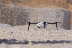
Taking this technology a step further, drones can be deployed and, at the touch of a button, quickly and automatically survey a site and the results can be uploaded into your system software for accurate, same-day measurements. Drones can also be used to measure stockpiles with up to 80% more accuracy than traditional survey methods. The use of this technology removes workers from active and dangerous environments. A typical site of approximately 30 acres can be flown in less than 30 minutes.
Several manufacturers are partnering with drone suppliers to provide tailored solutions. One such arrangement between Komatsu America Corp. and Propeller Aero Inc. is intended to boost the efficiency of construction jobsites using drone-powered mapping and analytics software. With drones becoming an increasingly common work-site tool, Komatsu identified aerial mapping and analytics as a key component of its Smart Construction initiative — a range of integrated hardware and software products designed to offer an end-to-end workflow for each phase of construction.
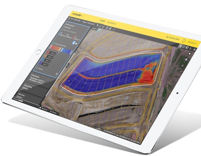
Propeller’s processing machinery processes thousands of drone images in hours and delivers the results as a cloud-based 3D model right to the user’s desktop or tablet. From there, powerful collaboration and analysis tools let users perform height, volume and slope calculations, and measure change over time to confirm that a project is on track.
Similarly, John Deere and drone service provider Kespry work as partners. Kespry developed a suite of capabilities that extends the value of drone-gathered data throughout the life cycle of planning, bidding and managing construction earthworks projects. Capabilities include grade planning and analysis, site and surface comparison including cut/fill visualization, and design plan development and compliance.
The Kespry aerial intelligence tools deliver:
- Faster and more accurate production of earthwork grading plans through on-demand drone data capture and analysis. Mass haul plans can be easily developed before projects begin with an entire site mapped and analyzed in hours. Tools also enable haul road planning.
- Reduced costs for earthwork project bids and increase win rates for contractors with grading project estimates and bids delivered much faster than with traditional estimating techniques. Ongoing operational costs are also reduced with on-demand cut/fill analysis enabling close management of the project and specific bid requests.
- More efficient and safer project operations with progress monitoring through daily drone flights. This enables design plan comparison through project plan overlay onto Kespry data, reducing the complexity and cost of rework. Safety can also be improved through close monitoring of change and analysis of grades around the site.