In one way, the world of concrete road and highway construction is slow to move forward. It takes time for the job to be done the right way. In another way, the construction of this country’s transportation infrastructure has accelerated drastically. One could say that the continued adoption of technology has allowed the contractors of the concrete road and highway construction industry to take a turn.
While it’s less of a trend and more of a traffic jam, there’s a lot of work but not enough people to do it all. Through material price fluctuations, tariffs, and the strained skill labor pool, the number of job biddings is up. A lot of construction work is still happening and it doesn’t appear to be slowing down. The work is there — it’s the how that work is being done is changing.
“One of the trends we’re seeing is how our contractors are getting more efficient — how they are able to complete the jobs faster,” says Kevin Garcia, general manager - civil specialty solutions at Trimble. “Sometimes that might mean buying the latest and greatest machines with built-in efficiencies, higher horsepower, and that are easier to use. In other cases, it’s applying technology. Any chance there’s an opportunity to improve efficiency and productivity, the industry will find it.”
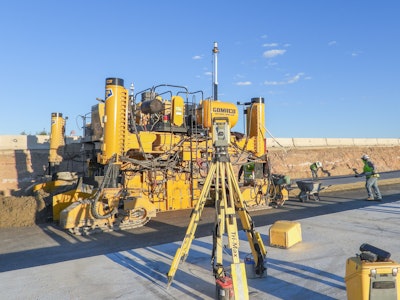
Stringless construction has been on the jobsite for quite some time. Putting out the string line, managing the trucks, and navigating the safety factors involved has been in the rearview mirror of concrete paving for a good while.
With rare exceptions, it’s either string or digital in concrete paving. While 10 years ago the adoption may have been (anecdotally) in the 25 to 30 percent range, it’s now well north of 50 percent. It’s rare, says Garcia, to see a concrete highway paving job where they’re not using technology of some kind.
That adoption will likely increase.
Allowing digital technology to help in the work can provide better control for planning and project management with access to the data needed to dial in yields, know the concrete needed to order, have an advised paving rate, and better size the concrete plant capacity. The use of e-ticketing has also accelerated from the COVID pandemic, providing contractors a digital trail of the plant, time, delivery rates, etc.
“The latest trend we’re starting to see take root is still pretty early, but there are now pockets of success in the way [contractors] are capturing the data to do the jobs,” says Garcia.
The traditional topographic survey with someone standing on the side of the road and measuring points is time-consuming, not to mention the safety risks involved. Data collected could be miles long and multiple lanes wide. Instead, mobile mapping units have gained a lot of popularity in the industry. Contractors are able to map during live traffic and not put a surveyor next to live traffic. For comparison, what might take 8 hours to survey a mile and a half of road can be collected in 15 minutes.
This technology was designed to vastly reduce the time to collect the information, improve safety, but also allow the collection of many data points applicable to other stakeholders in the project.
 Trimble
Garcia explains: “Normally, when you think about machine control, the contractor really just needs a surface and some site control to know where they are. They can then go out and execute. They can build the road.
But with some mobile mapping units, you can collect signage, overhead lines, fire hydrants, and more. The 360 camera and LIDAR package are looking everywhere.”
Often, contractors are concerned with “the vertical” more than anything: where the road needs to be, how thick the concrete needs to be paved, the cross slope, etc. Since more than just those details are being captured, that data might be valuable to the owner or the engineer designing the project and can aid in identifying potential clashes and conflicts in construction. Using that digital twin throughout the project can be critical.
This data can also be queried at a later date should metadata be needed: dates, the contractor(s) involved, the mix design, weather conditions, depth of paving, etc. That historical data can provide a better picture of what that cost of ownership will be and the lifespan of the constructed asset under normal use cases.
More about stringless concrete paving on ForConstructionPros.comWith Concrete Paving Equipment, the Word is Stringless - A look at how the changing technologies of concrete pavement equipment have adapted to the industry. Select Curb and Gutter Pavers to Meet Future Needs - Versatility to pour more than curb and gutter plus stringless capability should rank high on the list. Machine Control in Concrete Applications - With conventional stringliners, the process is vulnerable to human error. Automated and robotic stringlines help remove that human variable and increase accuracy. |
The challenge upon the industry is the burden of collecting data on the physical world — not just the road surface, but everything. While anyone can get in a vehicle that has a mobile mapper mounted on it, hit record, and drive around but what will be captured will be “relative accuracy.” What will be captured will be the building façade, the curb and barrier wall, the surface and striping, but Garcia says how accurately the data is captured as it related to a physical point or a hub on the ground is different.
Just like any surveying job, checks need to be done. In short, don’t measure with a broken ruler.
 Trimble
To do so, contractors have different tools at their disposal.
- Terrestrial Scanning – The terrestrial scanner is set upon a tripod to collect (or capture) a section and then moved down the road.
- Mobile Mapping – The mobile mapper is physically mounted to a vehicle and collects “looking” straight down. Depending on the unit, it can capture 12 ft. wide or a single lane at a time. Other models are able to capture multiple lanes at once.
- 360 Scanning – Depending on the quality of the equipment, another type of mobile mapping system uses a 360 camera and, while driving in the middle lane of a three-lane highway, can capture both the left and right lanes at once, plus the buildings, the overhead lines, everything.
Regardless, the scan may need additional control points (known points for the system to anchor onto) to keep the paver running accurately through the job. It’s not just controlling the paver’s elevation, slope, and grade, but helps steer the machine within millimeters of accuracy.
 Trimble
CAD & Model Creation
Where mobile mappers have taken the front seat in changing a 10-hour process of data point collection to 10 minutes (an exaggeration), is the model creation and applying that data into the CAD system. There has to be a digital technology to help do that legwork. Something has to inform contractors where the top of the pavement surface will be. Model optimization and AI are being applied here to aid in this regard.
“If I know what my cross slope, my thickness, and my smoothness needs to be, the computer is getting better and better at giving you a first pass,” says Garcia. Afterward, the designer and/or operator are only tweaking small things instead of the entire project.
While it hasn’t been heavily adopted in the highway space yet, Garcia says some advanced contractors are using an augmented reality view of the site using a mobile device like a smartphone or tablet.
Safety
One of the biggest impacts mapping technologies has had in road and highway construction has been the influence on safety.
For example, should an interstate need to be surveyed, one can close a lane at a time, surround the surveyor with safety cones, and divert traffic. While still next to live traffic, it’s reality – there will be vehicles all the time, even at night. Instead, with mobile mapping technologies, there are two benefits. One, you’re not putting a surveyor out there. Two, you’re not closing a lane, costing time, costing money, and disrupting the general public.
Instead, the surveyor can be in a safer environment driving with the flow of traffic without disrupting the public.
 Trimble
Miles Ahead
Consider the future of mapping technology in concrete paving to the technologies in consumer vehicles. Where at one time everything was done manually: the gas pedal, the brakes, the blinker, the headlights. After some time, we had cruise control and then adaptive cruise control. Then, lane guidance. And automatic high beams and even automatic headlights. Today, there are crash warnings and automated driving assistance systems, etc. While the construction industry is lagging behind the consumer world, it’s fair to say that it has the same expectations.
Already modern concrete pavers have integrated systems to control steering, grades, and elevation. “What we can’t control is when do the vibrators need to be on and off; what is the water spray or water add need to look like; is the texture correct – is it dry, is it too wet? Those are the harder problems to solve and this is where I think AI comes into play,” says Garcia.
Having the digital twin created with the metadata will likely shoulder a lot of this burden. That information will also be coupled with additional vital data such from the plant, the mix, the temperature, water content, schedule timing, who drove the truck, how thick contractors were paving on the day, and more. For example, say a road starts to present early failures years after placement, and engineers determine that something was off with the mix that day. Having that data may very well provide the opportunity to discover where else that mix was delivered to check and consider repairs.
“There’s a lot of stuff that goes on in an engineer’s day so we’re reliant on technology to solve that problem. I think you’ll see AI and the design optimization will be a big thing in the future,” says Garcia.

