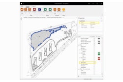
InSite Elevation Pro enables validation and production planning for users of the design platform with Production Cut and Fill Map. In past versions of the software, grids of cut and fill depth were overlaid on the shaded plan. While the provided shots were helpful, the contrast of the shading made interpreting between images difficult.
With the contouring engine in Elevation Pro, developers created a contoured based Production Cut and Fill Map. The contours provide data-based cut and fill with no need to interpret points. Contour labeling allows straightforward interpretation by those who have difficulty discerning colors.
The contours are selectable objects and can be used to define subgrades, site boundaries, stripping regions, etc.
The contour interval can be adjusted. Sites with very little elevation change can have a tight interval, and sites with a large range a larger interval. PDF or CAD files export contains toggleable Cut and Fill layers, making communication possible with various team members.