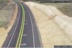
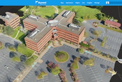
The latest version of the HCSS Aerial, drone-based data analytics platform contains design visualization and digital inspection enhancements.
- Displays designs on the model as 2D clamped to the ground
- Image Duplication Detection and Validations ensures uploaded image set doesn’t contain duplicates, analyzes location data and time of capture and warns if images do not have complete GPS information
- Ground Control Points cannot be set as a checkpoint if it is not marked on at least two different images, improving accuracy reports
- Auto geo-referencing models now support RTK flights
- Supports all leading design file formats for progress monitoring analytics and design overlay visualization for quality assurance
Learn more: HCSS Introduces New Version of Aerial for Heavy Civil Contractors
Fill out the form below to request more information about HCSS Aerial for Heavy Civil Contractors