EarthCam, a company specializing in live camera technology, content and services, has announced its redesigned VR Site Tour app. EarthCam has helped contractors capture and share detailed photos and videos of jobsites for more than two decades. Now, a ground-up redesign of the VR Site Tour platform enables more intuitive capturing and communicating of interior progress for owners and contractors.
VR Site Tour is specifically designed for straightforward reality capture for small-to-medium jobsites. For larger scale projects, EarthCam provides a range of construction imaging solutions – including professional onsite photography services.
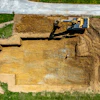
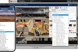
VR Site Tour interactive images are captured using a standard 360° camera, combined with EarthCam’s environmental sensor data, and automatically assembled into a virtual project tour. It converts a day’s worth of progress into 360° photos synching them directly to site plans, CAD drawings or 3D BIM models. All images are geo-tagged to properly align with the site plan. Immersive imagery provides evidence of actual live progress, reducing the need for site visits, preventing rework and saving time and money for stakeholders.
Combined with EarthCam’s construction cameras, VR Site Tour provides owners and contractors with documentation of jobsite progress. Interactive 360° images from VR inspections are captured without prior expertise or photographic knowledge.
VR Site Tour is integrated with EarthCam’s software, encompassing various aspects of visual data management for construction, including AI analytics, 3D/4D model integration, live streaming and time-lapse.
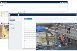
By uploading 360° imagery from VR Site Tour to project management platforms, such as Procore and Autodesk Build, contractors are able to add value and provide insight. With EarthCam, annotated 360° images can be pushed to 100% of image-ready Procore Daily Log sections, including Photos, RFIs and Change Events, to allow transparency and collaboration.