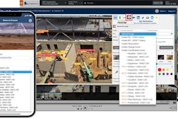
EarthCam has announced its integration with Esri ArcGIS Online, the Geographical Information Systems (GIS) platform. EarthCam’s live camera views deliver a new level of location intelligence direct to GIS maps. With EarthCam’s integration, users can access live-streaming views of mapped locations together with many layers of contextual data.
EarthCam’s camera streams are now mapped to each location in ArcGIS, providing a perspective of the surrounding environment. Live cameras have many geospatial use-cases to visualize data layers, such as active construction, climate change, crime and many more. Real-time video augments GIS for governmental projects, virtual tourism, ecological studies and scientific research.
“Adding live video to GIS metadata revolutionizes perspectives within interactive maps,” said Bill Sharp, SVP product development and strategy. “This combination of geography with up-to-the-minute visual data delivers unique insights utilizing EarthCam’s gigapixel panoramas, 8K imagery and epic time-lapse capabilities.”
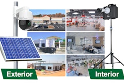
EarthCam deploys solar-powered, 4G camera rentals, professional installation and reality capture services for project management on jobsites.