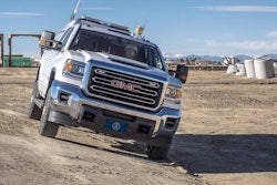
Trimble has announced the launch of the MX90 mobile mapping system for construction projects. With Trimble GNSS and inertial technology, when combined with Trimble field and office software, the Trimble MX90 provides a field-to-finish mobile mapping solution that enables workflows for data capture, processing and analysis. The vehicle- or train-mounted MX90 captures detailed laser scans and imagery—both panoramic and multi-angle.
Large-Scale Scanning and Mobile Mapping Projects
This immersive data, captured at highway speeds, can be processed to extract a range of deliverables for feature detection, inspection tasks and more.
High-resolution immersive imagery, high-density colorized point clouds with color projections and scene inspection capabilities enable new workflows, such as automatic crack detection. In urban environments or along rail tracks, users can zoom in and see small details on street signs, railway signals and other asset or as-built features. In open areas and large cities, users can capture more detail on distant objects, such as electrical or fiber poles.
 Trimble
Trimble MX90 System Features
- 360-degree panoramic and targeted cameras to capture high-resolution imagery of details, such as small or distant road and rail signs, telecommunications towers or cracks and holes in roads
- High-density colorized point clouds with color projections, through the collection of pixels. Dense point clouds, together with high-resolution imagery (panoramic and planar) and trajectories provide the basis for a range of deliverables, such as street scenes, road and rail asset details, elevation models, volume calculations, 3D city models and as-built surveys
- IMU combined with the IN-Fusion+ data processing technology to manage data in challenging GNSS environments
- Office software solutions to support multiple use cases and applications, such as road inspection workflows and integration into cloud-based applications for data sharing
 Trimble
The MX90 mobile mapping system leverages the Trimble field-to-finish workflow to capture, process and extract mobile mapping data.